|
|
|||||||||||||||||
| Point ID: 19 | Downloads | Plots | Site Data | Code: 05AA024 |
|
|
|||||||||||||||||
| Download | |
|---|---|
| Site Descriptor Information | Site Time Series Data |
| Link to all available data | |
| View: | Time Series | All |
| Units: | mm |
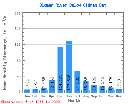
| Statistic | Jan | Feb | Mar | Apr | May | Jun | Jul | Aug | Sep | Oct | Nov | Dec | Annual |
|---|---|---|---|---|---|---|---|---|---|---|---|---|---|
| Mean | 8.03 | 8.73 | 12.44 | 32.16 | 114.19 | 127.81 | 54.28 | 28.77 | 20.13 | 16.25 | 13.18 | 9.94 | 36.99 |
| Standard Deviation | 2.77 | 4.38 | 7.86 | 16.87 | 48.45 | 67.70 | 30.34 | 19.83 | 10.37 | 7.61 | 7.91 | 5.29 | 12.45 |
| Min | 3.93 | 4.13 | 6.20 | 10.70 | 38.30 | 23.00 | 12.60 | 10.70 | 7.80 | 7.51 | 4.46 | 5.41 | 15.14 |
| Max | 14.60 | 29.20 | 38.50 | 79.00 | 242.00 | 305.00 | 159.00 | 90.80 | 56.20 | 40.30 | 40.30 | 30.00 | 66.01 |
| Coefficient of Variation | 0.35 | 0.50 | 0.63 | 0.52 | 0.42 | 0.53 | 0.56 | 0.69 | 0.52 | 0.47 | 0.60 | 0.53 | 0.34 |
 Return to R-Arctic Net Home Page