|
|
|||||||||||||||||
| Point ID: 19 | Downloads | Plots | Site Data | Code: 05AA024 |
|
|
|||||||||||||||||
| Download | |
|---|---|
| Site Descriptor Information | Site Time Series Data |
| Link to all available data | |
| View: | Time Series | All |
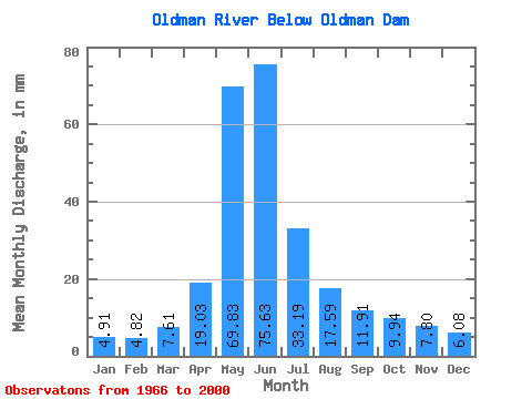
| Units: | m3/s |
| Statistic | Jan | Feb | Mar | Apr | May | Jun | Jul | Aug | Sep | Oct | Nov | Dec | Annual |
|---|---|---|---|---|---|---|---|---|---|---|---|---|---|
| Mean | 4.89 | 4.84 | 7.57 | 18.95 | 69.50 | 75.29 | 33.04 | 17.51 | 11.86 | 9.89 | 7.76 | 6.05 | 265.33 |
| Standard Deviation | 1.69 | 2.43 | 4.78 | 9.94 | 29.49 | 39.88 | 18.46 | 12.07 | 6.11 | 4.63 | 4.66 | 3.22 | 89.28 |
| Min | 2.39 | 2.29 | 3.77 | 6.30 | 23.31 | 13.55 | 7.67 | 6.51 | 4.59 | 4.57 | 2.63 | 3.29 | 108.63 |
| Max | 8.89 | 16.19 | 23.43 | 46.54 | 147.29 | 179.67 | 96.77 | 55.26 | 33.11 | 24.53 | 23.74 | 18.26 | 473.48 |
| Coefficient of Variation | 0.35 | 0.50 | 0.63 | 0.52 | 0.42 | 0.53 | 0.56 | 0.69 | 0.52 | 0.47 | 0.60 | 0.53 | 0.34 |
 Return to R-Arctic Net Home Page