|
|
|||||||||||||||||
| Point ID: 152 | Downloads | Plots | Site Data | Code: 05AE041 |
|
|
|||||||||||||||||
| Download | |
|---|---|
| Site Descriptor Information | Site Time Series Data |
| Link to all available data | |
| View: | Time Series | All |
| Units: | mm |
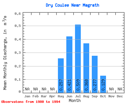
| Statistic | Jan | Feb | Mar | Apr | May | Jun | Jul | Aug | Sep | Oct | Nov | Dec | Annual |
|---|---|---|---|---|---|---|---|---|---|---|---|---|---|
| Mean | 0.26 | 0.42 | 0.51 | 0.37 | 0.28 | 0.13 | |||||||
| Standard Deviation | 0.20 | 0.13 | 0.12 | 0.11 | 0.10 | 0.07 | |||||||
| Min | 0.03 | 0.19 | 0.37 | 0.13 | 0.09 | 0.03 | |||||||
| Max | 0.77 | 0.73 | 0.79 | 0.54 | 0.40 | 0.23 | |||||||
| Coefficient of Variation | 0.77 | 0.30 | 0.24 | 0.30 | 0.36 | 0.51 |
 Return to R-Arctic Net Home Page