|
|
|||||||||||||||||
| Point ID: 152 | Downloads | Plots | Site Data | Code: 05AE041 |
|
|
|||||||||||||||||
| Download | |
|---|---|
| Site Descriptor Information | Site Time Series Data |
| Link to all available data | |
| View: | Time Series | All |
| Units: | m3/s |
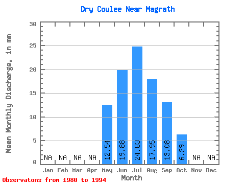
| Statistic | Jan | Feb | Mar | Apr | May | Jun | Jul | Aug | Sep | Oct | Nov | Dec | Annual |
|---|---|---|---|---|---|---|---|---|---|---|---|---|---|
| Mean | 12.55 | 19.89 | 24.85 | 17.94 | 13.06 | 6.28 | |||||||
| Standard Deviation | 9.65 | 6.01 | 5.91 | 5.46 | 4.71 | 3.23 | |||||||
| Min | 1.27 | 8.83 | 17.95 | 6.49 | 4.06 | 1.42 | |||||||
| Max | 37.41 | 34.51 | 38.29 | 26.20 | 18.93 | 11.46 | |||||||
| Coefficient of Variation | 0.77 | 0.30 | 0.24 | 0.30 | 0.36 | 0.51 |
 Return to R-Arctic Net Home Page