|
|
|||||||||||||||||
| Point ID: 148 | Downloads | Plots | Site Data | Code: 05AE037 |
|
|
|||||||||||||||||
| Download | |
|---|---|
| Site Descriptor Information | Site Time Series Data |
| Link to all available data | |
| View: | Time Series | All |
| Units: | mm |
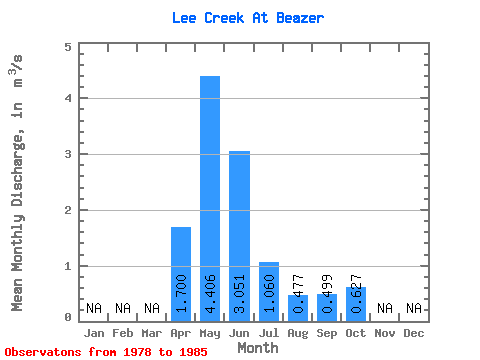
| Statistic | Jan | Feb | Mar | Apr | May | Jun | Jul | Aug | Sep | Oct | Nov | Dec | Annual |
|---|---|---|---|---|---|---|---|---|---|---|---|---|---|
| Mean | 1.70 | 4.41 | 3.05 | 1.06 | 0.48 | 0.50 | 0.63 | ||||||
| Standard Deviation | 3.18 | 1.68 | 0.68 | 0.31 | 0.46 | 0.74 | |||||||
| Min | 1.70 | 1.06 | 0.98 | 0.36 | 0.17 | 0.14 | 0.16 | ||||||
| Max | 1.70 | 10.10 | 5.38 | 2.13 | 1.10 | 1.24 | 2.36 | ||||||
| Coefficient of Variation | 0.72 | 0.55 | 0.64 | 0.66 | 0.93 | 1.17 |
 Return to R-Arctic Net Home Page