|
|
|||||||||||||||||
| Point ID: 148 | Downloads | Plots | Site Data | Code: 05AE037 |
|
|
|||||||||||||||||
| Download | |
|---|---|
| Site Descriptor Information | Site Time Series Data |
| Link to all available data | |
| View: | Time Series | All |
| Units: | m3/s |
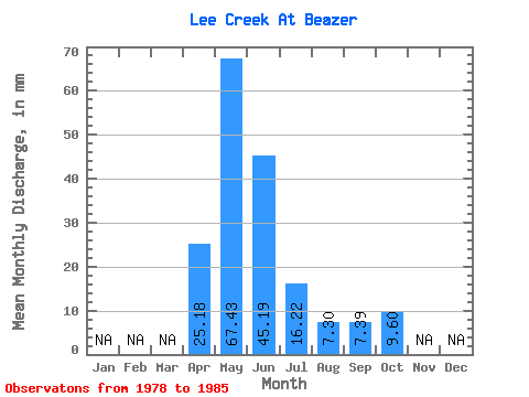
| Statistic | Jan | Feb | Mar | Apr | May | Jun | Jul | Aug | Sep | Oct | Nov | Dec | Annual |
|---|---|---|---|---|---|---|---|---|---|---|---|---|---|
| Mean | 25.18 | 67.42 | 45.19 | 16.23 | 7.29 | 7.40 | 9.60 | ||||||
| Standard Deviation | 48.70 | 24.89 | 10.41 | 4.81 | 6.85 | 11.27 | |||||||
| Min | 25.18 | 16.22 | 14.52 | 5.52 | 2.56 | 2.06 | 2.43 | ||||||
| Max | 25.18 | 154.56 | 79.69 | 32.59 | 16.83 | 18.37 | 36.12 | ||||||
| Coefficient of Variation | 0.72 | 0.55 | 0.64 | 0.66 | 0.93 | 1.17 |
 Return to R-Arctic Net Home Page