|
|
|||||||||||||||||
| Point ID: 145 | Downloads | Plots | Site Data | Code: 05AE031 |
|
|
|||||||||||||||||
| Download | |
|---|---|
| Site Descriptor Information | Site Time Series Data |
| Link to all available data | |
| View: | Time Series | All |
| Units: | mm |
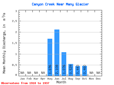
| Statistic | Jan | Feb | Mar | Apr | May | Jun | Jul | Aug | Sep | Oct | Nov | Dec | Annual |
|---|---|---|---|---|---|---|---|---|---|---|---|---|---|
| Mean | 1.70 | 2.11 | 1.08 | 0.54 | 0.44 | 0.46 | |||||||
| Standard Deviation | 0.56 | 0.69 | 0.36 | 0.15 | 0.29 | 0.31 | |||||||
| Min | 0.82 | 0.97 | 0.54 | 0.36 | 0.18 | 0.18 | |||||||
| Max | 2.83 | 3.37 | 1.91 | 1.00 | 1.45 | 1.12 | |||||||
| Coefficient of Variation | 0.33 | 0.33 | 0.34 | 0.28 | 0.66 | 0.68 |
 Return to R-Arctic Net Home Page