|
|
|||||||||||||||||
| Point ID: 145 | Downloads | Plots | Site Data | Code: 05AE031 |
|
|
|||||||||||||||||
| Download | |
|---|---|
| Site Descriptor Information | Site Time Series Data |
| Link to all available data | |
| View: | Time Series | All |
| Units: | m3/s |
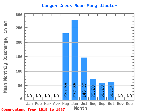
| Statistic | Jan | Feb | Mar | Apr | May | Jun | Jul | Aug | Sep | Oct | Nov | Dec | Annual |
|---|---|---|---|---|---|---|---|---|---|---|---|---|---|
| Mean | 230.56 | 277.32 | 146.30 | 73.28 | 58.35 | 62.57 | |||||||
| Standard Deviation | 76.83 | 90.53 | 49.35 | 20.12 | 38.22 | 42.37 | |||||||
| Min | 112.15 | 127.89 | 73.00 | 49.07 | 23.29 | 25.01 | |||||||
| Max | 384.71 | 443.40 | 259.64 | 135.67 | 190.78 | 152.25 | |||||||
| Coefficient of Variation | 0.33 | 0.33 | 0.34 | 0.28 | 0.66 | 0.68 |
 Return to R-Arctic Net Home Page