|
|
|||||||||||||||||
| Point ID: 126 | Downloads | Plots | Site Data | Code: 05AE007 |
|
|
|||||||||||||||||
| Download | |
|---|---|
| Site Descriptor Information | Site Time Series Data |
| Link to all available data | |
| View: | Time Series | All |
| Units: | mm |
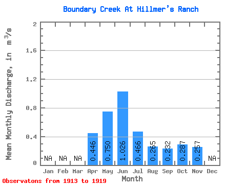
| Statistic | Jan | Feb | Mar | Apr | May | Jun | Jul | Aug | Sep | Oct | Nov | Dec | Annual |
|---|---|---|---|---|---|---|---|---|---|---|---|---|---|
| Mean | 0.45 | 0.75 | 1.03 | 0.47 | 0.27 | 0.23 | 0.29 | 0.26 | |||||
| Standard Deviation | 0.20 | 0.54 | 1.01 | 0.54 | 0.28 | 0.24 | 0.23 | ||||||
| Min | 0.23 | 0.15 | 0.05 | 0.01 | 0.00 | 0.00 | 0.02 | 0.26 | |||||
| Max | 0.72 | 1.69 | 2.50 | 1.55 | 0.83 | 0.71 | 0.70 | 0.26 | |||||
| Coefficient of Variation | 0.46 | 0.71 | 0.98 | 1.15 | 1.04 | 1.02 | 0.79 |
 Return to R-Arctic Net Home Page