|
|
|||||||||||||||||
| Point ID: 126 | Downloads | Plots | Site Data | Code: 05AE007 |
|
|
|||||||||||||||||
| Download | |
|---|---|
| Site Descriptor Information | Site Time Series Data |
| Link to all available data | |
| View: | Time Series | All |
| Units: | m3/s |
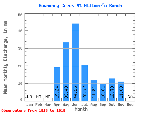
| Statistic | Jan | Feb | Mar | Apr | May | Jun | Jul | Aug | Sep | Oct | Nov | Dec | Annual |
|---|---|---|---|---|---|---|---|---|---|---|---|---|---|
| Mean | 19.23 | 33.44 | 44.23 | 20.76 | 11.82 | 9.99 | 12.79 | 11.09 | |||||
| Standard Deviation | 8.79 | 23.91 | 43.54 | 23.96 | 12.31 | 10.22 | 10.11 | ||||||
| Min | 9.88 | 6.55 | 2.11 | 0.40 | 0.00 | 0.00 | 1.07 | 11.09 | |||||
| Max | 31.01 | 75.32 | 107.84 | 69.08 | 36.81 | 30.84 | 31.15 | 11.09 | |||||
| Coefficient of Variation | 0.46 | 0.71 | 0.98 | 1.15 | 1.04 | 1.02 | 0.79 |
 Return to R-Arctic Net Home Page