|
|
|||||||||||||||||
| Point ID: 124 | Downloads | Plots | Site Data | Code: 05AE005 |
|
|
|||||||||||||||||
| Download | |
|---|---|
| Site Descriptor Information | Site Time Series Data |
| Link to all available data | |
| View: | Time Series | All |
| Units: | mm |
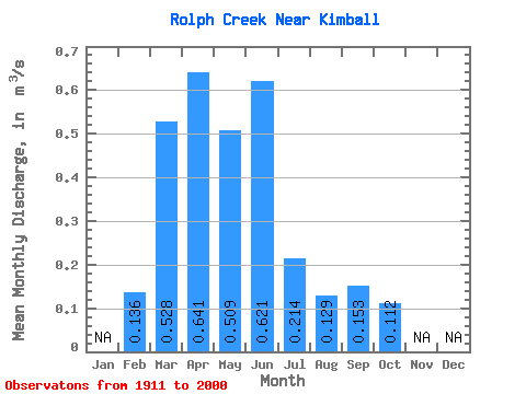
| Statistic | Jan | Feb | Mar | Apr | May | Jun | Jul | Aug | Sep | Oct | Nov | Dec | Annual |
|---|---|---|---|---|---|---|---|---|---|---|---|---|---|
| Mean | 0.14 | 0.53 | 0.64 | 0.51 | 0.62 | 0.21 | 0.13 | 0.15 | 0.11 | ||||
| Standard Deviation | 0.13 | 0.59 | 0.65 | 0.58 | 1.10 | 0.33 | 0.15 | 0.21 | 0.12 | ||||
| Min | 0.04 | 0.00 | 0.03 | 0.01 | 0.00 | 0.00 | 0.00 | 0.00 | 0.01 | ||||
| Max | 0.32 | 2.96 | 3.00 | 2.76 | 6.68 | 1.70 | 0.89 | 1.17 | 0.67 | ||||
| Coefficient of Variation | 0.99 | 1.11 | 1.02 | 1.13 | 1.77 | 1.52 | 1.17 | 1.39 | 1.12 |
 Return to R-Arctic Net Home Page