|
|
|||||||||||||||||
| Point ID: 124 | Downloads | Plots | Site Data | Code: 05AE005 |
|
|
|||||||||||||||||
| Download | |
|---|---|
| Site Descriptor Information | Site Time Series Data |
| Link to all available data | |
| View: | Time Series | All |
| Units: | m3/s |
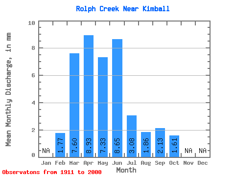
| Statistic | Jan | Feb | Mar | Apr | May | Jun | Jul | Aug | Sep | Oct | Nov | Dec | Annual |
|---|---|---|---|---|---|---|---|---|---|---|---|---|---|
| Mean | 1.50 | 6.40 | 7.52 | 6.17 | 7.29 | 2.59 | 1.56 | 1.80 | 1.35 | ||||
| Standard Deviation | 1.48 | 7.14 | 7.67 | 6.99 | 12.87 | 3.95 | 1.84 | 2.49 | 1.52 | ||||
| Min | 0.40 | 0.00 | 0.29 | 0.09 | 0.02 | 0.00 | 0.00 | 0.00 | 0.06 | ||||
| Max | 3.57 | 35.87 | 35.19 | 33.45 | 78.35 | 20.60 | 10.80 | 13.72 | 8.07 | ||||
| Coefficient of Variation | 0.99 | 1.11 | 1.02 | 1.13 | 1.77 | 1.52 | 1.17 | 1.39 | 1.12 |
 Return to R-Arctic Net Home Page