|
|
|||||||||||||||||
| Point ID: 121 | Downloads | Plots | Site Data | Code: 05AE002 |
|
|
|||||||||||||||||
| Download | |
|---|---|
| Site Descriptor Information | Site Time Series Data |
| Link to all available data | |
| View: | Time Series | All |
| Units: | mm |
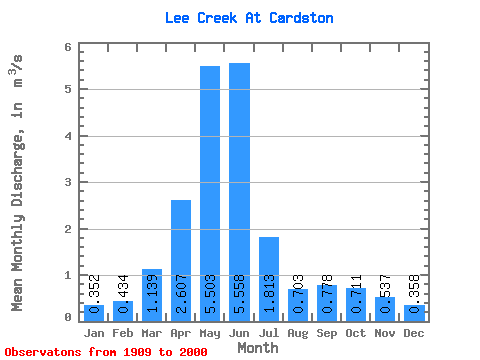
| Statistic | Jan | Feb | Mar | Apr | May | Jun | Jul | Aug | Sep | Oct | Nov | Dec | Annual |
|---|---|---|---|---|---|---|---|---|---|---|---|---|---|
| Mean | 0.35 | 0.43 | 1.14 | 2.61 | 5.50 | 5.56 | 1.81 | 0.70 | 0.78 | 0.71 | 0.54 | 0.36 | 1.70 |
| Standard Deviation | 0.38 | 0.39 | 0.91 | 1.53 | 3.99 | 5.06 | 1.64 | 0.79 | 1.23 | 0.77 | 0.52 | 0.27 | 1.04 |
| Min | 0.01 | 0.01 | 0.09 | 0.51 | 0.49 | 0.37 | 0.06 | 0.01 | 0.06 | 0.14 | 0.13 | 0.07 | 0.36 |
| Max | 2.79 | 2.23 | 4.30 | 8.29 | 19.90 | 23.20 | 8.79 | 5.19 | 6.91 | 4.66 | 3.26 | 1.30 | 5.44 |
| Coefficient of Variation | 1.08 | 0.89 | 0.80 | 0.59 | 0.73 | 0.91 | 0.91 | 1.13 | 1.58 | 1.08 | 0.97 | 0.76 | 0.61 |
 Return to R-Arctic Net Home Page