|
|
|||||||||||||||||
| Point ID: 121 | Downloads | Plots | Site Data | Code: 05AE002 |
|
|
|||||||||||||||||
| Download | |
|---|---|
| Site Descriptor Information | Site Time Series Data |
| Link to all available data | |
| View: | Time Series | All |
| Units: | m3/s |
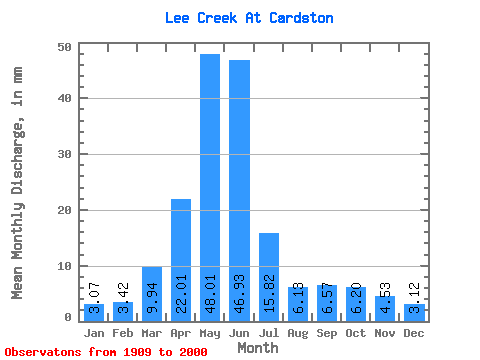
| Statistic | Jan | Feb | Mar | Apr | May | Jun | Jul | Aug | Sep | Oct | Nov | Dec | Annual |
|---|---|---|---|---|---|---|---|---|---|---|---|---|---|
| Mean | 3.07 | 3.45 | 9.93 | 22.01 | 48.01 | 46.93 | 15.81 | 6.13 | 6.57 | 6.20 | 4.54 | 3.12 | 175.08 |
| Standard Deviation | 3.33 | 3.08 | 7.93 | 12.94 | 34.84 | 42.73 | 14.32 | 6.92 | 10.40 | 6.72 | 4.40 | 2.38 | 107.32 |
| Min | 0.05 | 0.07 | 0.77 | 4.26 | 4.26 | 3.10 | 0.48 | 0.12 | 0.47 | 1.24 | 1.06 | 0.57 | 37.45 |
| Max | 24.34 | 17.72 | 37.51 | 69.99 | 173.59 | 195.88 | 76.68 | 45.27 | 58.34 | 40.65 | 27.52 | 11.34 | 559.43 |
| Coefficient of Variation | 1.08 | 0.89 | 0.80 | 0.59 | 0.73 | 0.91 | 0.91 | 1.13 | 1.58 | 1.08 | 0.97 | 0.76 | 0.61 |
 Return to R-Arctic Net Home Page