|
|
|||||||||||||||||
| Point ID: 109 | Downloads | Plots | Site Data | Code: 05AD033 |
|
|
|||||||||||||||||
| Download | |
|---|---|
| Site Descriptor Information | Site Time Series Data |
| Link to all available data | |
| View: | Time Series | All |
| Units: | mm |
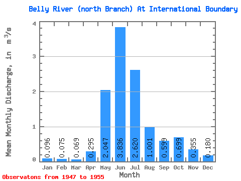
| Statistic | Jan | Feb | Mar | Apr | May | Jun | Jul | Aug | Sep | Oct | Nov | Dec | Annual |
|---|---|---|---|---|---|---|---|---|---|---|---|---|---|
| Mean | 0.10 | 0.07 | 0.07 | 0.29 | 2.05 | 3.84 | 2.62 | 1.00 | 0.60 | 0.70 | 0.35 | 0.18 | 0.99 |
| Standard Deviation | 0.04 | 0.05 | 0.02 | 0.21 | 0.65 | 1.14 | 1.01 | 0.32 | 0.39 | 0.53 | 0.21 | 0.11 | 0.22 |
| Min | 0.03 | 0.02 | 0.05 | 0.09 | 0.91 | 2.33 | 1.16 | 0.46 | 0.22 | 0.14 | 0.05 | 0.04 | 0.70 |
| Max | 0.14 | 0.15 | 0.09 | 0.66 | 2.80 | 5.37 | 3.86 | 1.47 | 1.51 | 1.62 | 0.68 | 0.27 | 1.23 |
| Coefficient of Variation | 0.45 | 0.61 | 0.28 | 0.71 | 0.32 | 0.30 | 0.39 | 0.32 | 0.65 | 0.75 | 0.60 | 0.59 | 0.22 |
 Return to R-Arctic Net Home Page