|
|
|||||||||||||||||
| Point ID: 109 | Downloads | Plots | Site Data | Code: 05AD033 |
|
|
|||||||||||||||||
| Download | |
|---|---|
| Site Descriptor Information | Site Time Series Data |
| Link to all available data | |
| View: | Time Series | All |
| Units: | m3/s |
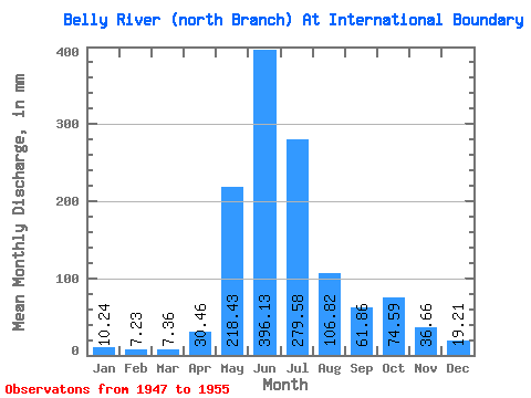
| Statistic | Jan | Feb | Mar | Apr | May | Jun | Jul | Aug | Sep | Oct | Nov | Dec | Annual |
|---|---|---|---|---|---|---|---|---|---|---|---|---|---|
| Mean | 10.22 | 7.31 | 7.38 | 30.43 | 218.37 | 396.16 | 279.54 | 106.76 | 61.84 | 74.54 | 36.67 | 19.20 | 1239.22 |
| Standard Deviation | 4.64 | 4.49 | 2.08 | 21.69 | 69.36 | 118.02 | 108.26 | 33.92 | 39.99 | 56.04 | 22.14 | 11.40 | 277.20 |
| Min | 2.88 | 1.75 | 5.33 | 8.78 | 97.52 | 240.61 | 123.76 | 49.40 | 22.61 | 15.36 | 5.27 | 4.05 | 880.47 |
| Max | 14.62 | 14.19 | 10.03 | 67.74 | 298.74 | 554.54 | 411.84 | 156.84 | 155.93 | 172.84 | 70.43 | 28.81 | 1547.93 |
| Coefficient of Variation | 0.45 | 0.61 | 0.28 | 0.71 | 0.32 | 0.30 | 0.39 | 0.32 | 0.65 | 0.75 | 0.60 | 0.59 | 0.22 |
 Return to R-Arctic Net Home Page