|
|
|||||||||||||||||
| Point ID: 108 | Downloads | Plots | Site Data | Code: 05AD032 |
|
|
|||||||||||||||||
| Download | |
|---|---|
| Site Descriptor Information | Site Time Series Data |
| Link to all available data | |
| View: | Time Series | All |
| Units: | mm |
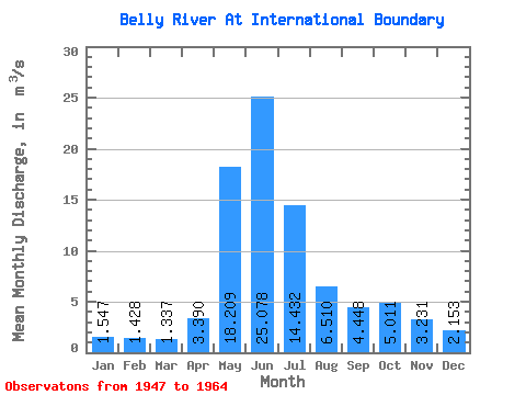
| Statistic | Jan | Feb | Mar | Apr | May | Jun | Jul | Aug | Sep | Oct | Nov | Dec | Annual |
|---|---|---|---|---|---|---|---|---|---|---|---|---|---|
| Mean | 1.55 | 1.43 | 1.34 | 3.39 | 18.21 | 25.08 | 14.43 | 6.51 | 4.45 | 5.01 | 3.23 | 2.15 | 7.43 |
| Standard Deviation | 0.55 | 0.55 | 0.34 | 1.38 | 4.61 | 8.19 | 4.96 | 1.48 | 1.89 | 2.88 | 1.41 | 0.91 | 1.38 |
| Min | 0.56 | 0.55 | 0.82 | 1.64 | 8.60 | 15.00 | 8.15 | 4.07 | 2.76 | 1.62 | 1.06 | 0.69 | 5.49 |
| Max | 2.65 | 2.59 | 2.04 | 6.50 | 26.30 | 48.30 | 24.40 | 9.82 | 9.38 | 10.70 | 6.23 | 4.09 | 9.07 |
| Coefficient of Variation | 0.35 | 0.38 | 0.26 | 0.41 | 0.25 | 0.33 | 0.34 | 0.23 | 0.42 | 0.57 | 0.44 | 0.42 | 0.18 |
 Return to R-Arctic Net Home Page