|
|
|||||||||||||||||
| Point ID: 108 | Downloads | Plots | Site Data | Code: 05AD032 |
|
|
|||||||||||||||||
| Download | |
|---|---|
| Site Descriptor Information | Site Time Series Data |
| Link to all available data | |
| View: | Time Series | All |
| Units: | m3/s |
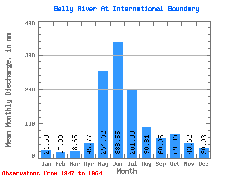
| Statistic | Jan | Feb | Mar | Apr | May | Jun | Jul | Aug | Sep | Oct | Nov | Dec | Annual |
|---|---|---|---|---|---|---|---|---|---|---|---|---|---|
| Mean | 21.58 | 18.15 | 18.64 | 45.77 | 253.98 | 338.55 | 201.29 | 90.80 | 60.05 | 69.89 | 43.62 | 30.03 | 1220.87 |
| Standard Deviation | 7.65 | 6.96 | 4.76 | 18.63 | 64.25 | 110.51 | 69.14 | 20.57 | 25.45 | 40.18 | 19.03 | 12.63 | 226.06 |
| Min | 7.78 | 6.98 | 11.39 | 22.14 | 119.95 | 202.50 | 113.68 | 56.77 | 37.26 | 22.60 | 14.31 | 9.58 | 902.01 |
| Max | 36.96 | 32.91 | 28.45 | 87.75 | 366.83 | 652.05 | 340.33 | 136.97 | 126.63 | 149.24 | 84.11 | 57.05 | 1490.20 |
| Coefficient of Variation | 0.35 | 0.38 | 0.26 | 0.41 | 0.25 | 0.33 | 0.34 | 0.23 | 0.42 | 0.57 | 0.44 | 0.42 | 0.18 |
 Return to R-Arctic Net Home Page