|
|
|||||||||||||||||
| Point ID: 9666 | Downloads | Plots | Site Data | Code: 05049000 |
|
|
|||||||||||||||||
| Download | |
|---|---|
| Site Descriptor Information | Site Time Series Data |
| Link to all available data | |
| View: | Time Series | All |
| Units: | m3/s |
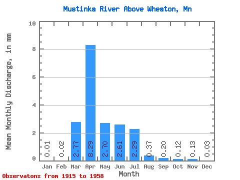
| Statistic | Jan | Feb | Mar | Apr | May | Jun | Jul | Aug | Sep | Oct | Nov | Dec | Annual |
|---|---|---|---|---|---|---|---|---|---|---|---|---|---|
| Mean | 0.01 | 0.02 | 2.77 | 8.29 | 2.70 | 2.61 | 2.29 | 0.37 | 0.20 | 0.12 | 0.13 | 0.03 | 19.83 |
| Standard Deviation | 0.03 | 0.06 | 3.96 | 12.91 | 4.50 | 4.43 | 5.54 | 0.80 | 0.39 | 0.24 | 0.28 | 0.05 | 20.37 |
| Min | 0.00 | 0.00 | 0.00 | 0.05 | 0.01 | 0.00 | 0.00 | 0.00 | 0.00 | 0.00 | 0.00 | 0.00 | 0.08 |
| Max | 0.14 | 0.36 | 15.73 | 61.81 | 20.64 | 18.32 | 29.67 | 3.91 | 1.54 | 1.12 | 1.45 | 0.16 | 75.61 |
| Coefficient of Variation | 2.14 | 2.95 | 1.43 | 1.56 | 1.67 | 1.69 | 2.42 | 2.19 | 1.92 | 2.00 | 2.13 | 1.34 | 1.03 |
 Return to R-Arctic Net Home Page