|
|
|||||||||||||||||
| Point ID: 9666 | Downloads | Plots | Site Data | Code: 05049000 |
|
|
|||||||||||||||||
| Download | |
|---|---|
| Site Descriptor Information | Site Time Series Data |
| Link to all available data | |
| View: | Time Series | All |
| Units: | mm |
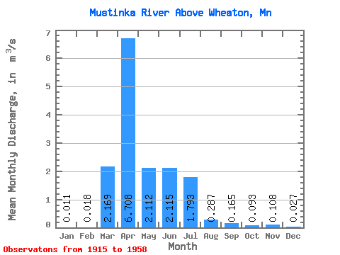
| Statistic | Jan | Feb | Mar | Apr | May | Jun | Jul | Aug | Sep | Oct | Nov | Dec | Annual |
|---|---|---|---|---|---|---|---|---|---|---|---|---|---|
| Mean | 0.01 | 0.02 | 2.17 | 6.71 | 2.11 | 2.12 | 1.79 | 0.29 | 0.17 | 0.09 | 0.11 | 0.03 | 1.32 |
| Standard Deviation | 0.02 | 0.05 | 3.11 | 10.45 | 3.52 | 3.58 | 4.34 | 0.63 | 0.32 | 0.19 | 0.23 | 0.04 | 1.35 |
| Min | 0.00 | 0.00 | 0.00 | 0.04 | 0.00 | 0.00 | 0.00 | 0.00 | 0.00 | 0.00 | 0.00 | 0.00 | 0.01 |
| Max | 0.11 | 0.31 | 12.33 | 50.03 | 16.17 | 14.83 | 23.24 | 3.07 | 1.25 | 0.88 | 1.17 | 0.13 | 5.03 |
| Coefficient of Variation | 2.14 | 2.95 | 1.43 | 1.56 | 1.67 | 1.69 | 2.42 | 2.19 | 1.92 | 2.00 | 2.13 | 1.34 | 1.03 |
 Return to R-Arctic Net Home Page