|
|
|||||||||||||||||
| Point ID: 9315 | Downloads | Plots | Site Data | Code: 15056100 |
|
|
|||||||||||||||||
| Download | |
|---|---|
| Site Descriptor Information | Site Time Series Data |
| Link to all available data | |
| View: | Time Series | All |
| Units: | m3/s |
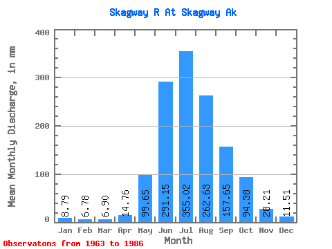
| Statistic | Jan | Feb | Mar | Apr | May | Jun | Jul | Aug | Sep | Oct | Nov | Dec | Annual |
|---|---|---|---|---|---|---|---|---|---|---|---|---|---|
| Mean | 8.79 | 6.84 | 6.90 | 14.76 | 99.63 | 291.15 | 354.97 | 262.59 | 157.66 | 94.36 | 28.21 | 11.51 | 1325.08 |
| Standard Deviation | 7.27 | 5.35 | 4.70 | 7.13 | 54.18 | 66.09 | 115.49 | 70.60 | 81.77 | 69.40 | 20.84 | 5.72 | 305.88 |
| Min | 2.81 | 2.30 | 1.71 | 5.42 | 40.79 | 183.71 | 165.69 | 127.32 | 63.37 | 31.02 | 6.57 | 3.84 | 954.84 |
| Max | 37.02 | 24.34 | 20.39 | 36.31 | 298.52 | 432.76 | 648.68 | 429.92 | 412.64 | 353.33 | 73.80 | 20.91 | 2084.66 |
| Coefficient of Variation | 0.83 | 0.78 | 0.68 | 0.48 | 0.54 | 0.23 | 0.33 | 0.27 | 0.52 | 0.73 | 0.74 | 0.50 | 0.23 |
 Return to R-Arctic Net Home Page