|
|
|||||||||||||||||
| Point ID: 9315 | Downloads | Plots | Site Data | Code: 15056100 |
|
|
|||||||||||||||||
| Download | |
|---|---|
| Site Descriptor Information | Site Time Series Data |
| Link to all available data | |
|
|
| View: | Statistics | Time Series |
| Units: | m3/s |
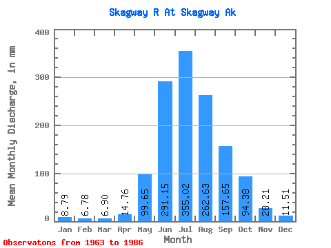
| Statistic | Jan | Feb | Mar | Apr | May | Jun | Jul | Aug | Sep | Oct | Nov | Dec | Annual |
|---|---|---|---|---|---|---|---|---|---|---|---|---|---|
| Mean | 8.79 | 6.84 | 6.90 | 14.76 | 99.63 | 291.15 | 354.97 | 262.59 | 157.66 | 94.36 | 28.21 | 11.51 | 1325.08 |
| Standard Deviation | 7.27 | 5.35 | 4.70 | 7.13 | 54.18 | 66.09 | 115.49 | 70.60 | 81.77 | 69.40 | 20.84 | 5.72 | 305.88 |
| Min | 2.81 | 2.30 | 1.71 | 5.42 | 40.79 | 183.71 | 165.69 | 127.32 | 63.37 | 31.02 | 6.57 | 3.84 | 954.84 |
| Max | 37.02 | 24.34 | 20.39 | 36.31 | 298.52 | 432.76 | 648.68 | 429.92 | 412.64 | 353.33 | 73.80 | 20.91 | 2084.66 |
| Coefficient of Variation | 0.83 | 0.78 | 0.68 | 0.48 | 0.54 | 0.23 | 0.33 | 0.27 | 0.52 | 0.73 | 0.74 | 0.50 | 0.23 |
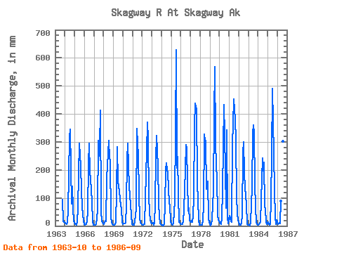
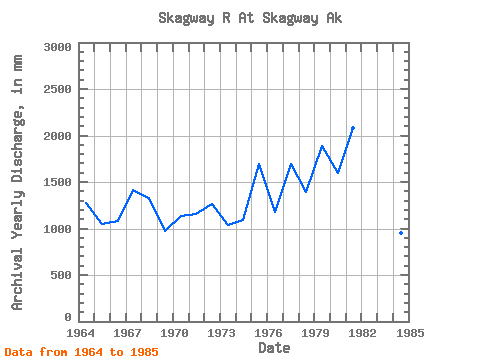
| Year | Jan | Feb | Mar | Apr | May | Jun | Jul | Aug | Sep | Oct | Nov | Dec | Annual | 1963 | 95.98 | 16.59 | 14.31 | 1964 | 9.76 | 7.10 | 6.36 | 14.05 | 56.47 | 316.65 | 357.00 | 210.80 | 79.46 | 147.29 | 64.26 | 16.25 | 1278.54 | 1965 | 5.57 | 4.97 | 4.44 | 14.26 | 68.53 | 183.71 | 304.88 | 218.26 | 126.00 | 70.02 | 40.27 | 20.08 | 1054.32 | 1966 | 5.73 | 4.44 | 6.07 | 18.89 | 52.31 | 222.44 | 305.40 | 198.28 | 166.09 | 92.88 | 14.08 | 4.82 | 1086.05 | 1967 | 3.54 | 3.38 | 3.30 | 5.42 | 56.02 | 305.58 | 256.92 | 292.22 | 412.64 | 52.29 | 16.59 | 10.03 | 1416.96 | 1968 | 5.83 | 11.41 | 20.39 | 15.07 | 174.34 | 262.22 | 314.31 | 248.74 | 235.74 | 32.44 | 12.78 | 6.84 | 1334.33 | 1969 | 2.81 | 2.63 | 5.38 | 14.94 | 122.84 | 281.38 | 165.69 | 127.32 | 97.66 | 76.09 | 61.59 | 15.04 | 971.01 | 1970 | 7.73 | 8.13 | 7.93 | 11.48 | 76.41 | 235.67 | 304.96 | 222.82 | 142.33 | 78.47 | 36.04 | 6.19 | 1132.41 | 1971 | 3.77 | 3.31 | 3.64 | 17.39 | 64.66 | 347.90 | 301.46 | 263.28 | 110.13 | 31.02 | 11.68 | 7.53 | 1161.06 | 1972 | 4.53 | 3.68 | 6.48 | 6.72 | 98.66 | 268.43 | 381.27 | 321.04 | 103.80 | 51.10 | 20.43 | 11.90 | 1268.50 | 1973 | 10.13 | 10.75 | 4.37 | 10.24 | 82.08 | 239.71 | 332.31 | 222.43 | 77.78 | 36.98 | 9.39 | 5.86 | 1035.34 | 1974 | 3.95 | 4.06 | 1.72 | 9.60 | 78.92 | 199.45 | 232.05 | 204.90 | 189.27 | 82.88 | 73.80 | 16.38 | 1093.11 | 1975 | 8.70 | 5.56 | 4.85 | 11.79 | 91.24 | 339.35 | 648.68 | 214.84 | 246.48 | 114.44 | 13.68 | 8.66 | 1698.10 | 1976 | 7.12 | 6.14 | 5.67 | 15.92 | 61.54 | 200.98 | 298.98 | 287.06 | 159.36 | 56.18 | 65.08 | 20.09 | 1177.87 | 1977 | 13.84 | 18.78 | 14.47 | 36.31 | 105.18 | 359.92 | 452.83 | 429.92 | 155.38 | 93.80 | 22.39 | 4.67 | 1697.38 | 1978 | 3.27 | 3.61 | 3.91 | 20.54 | 76.73 | 327.53 | 314.03 | 314.98 | 131.22 | 165.57 | 24.95 | 13.90 | 1391.91 | 1979 | 5.99 | 2.30 | 6.34 | 24.28 | 128.48 | 391.91 | 586.89 | 318.45 | 206.37 | 182.48 | 33.72 | 16.58 | 1891.27 | 1980 | 12.01 | 8.72 | 7.45 | 26.35 | 132.69 | 432.76 | 334.45 | 201.16 | 63.37 | 353.33 | 27.76 | 9.23 | 1599.21 | 1981 | 37.02 | 24.34 | 16.09 | 13.93 | 298.52 | 364.46 | 469.05 | 392.96 | 307.42 | 106.06 | 46.87 | 19.30 | 2084.66 | 1982 | 15.74 | 3.15 | 3.11 | 9.04 | 40.79 | 261.67 | 309.75 | 195.86 | 136.00 | 82.50 | 7.28 | 4.53 | 1064.05 | 1983 | 4.09 | 2.44 | 1.71 | 13.58 | 142.91 | 329.19 | 371.28 | 342.36 | 150.61 | 68.25 | 11.23 | 3.84 | 1432.31 | 1984 | 5.03 | 5.29 | 8.49 | 15.27 | 95.65 | 241.58 | 202.89 | 234.56 | 67.33 | 64.91 | 11.88 | 7.73 | 954.84 | 1985 | 14.88 | 5.98 | 4.34 | 6.61 | 94.31 | 251.31 | 506.83 | 265.20 | 126.84 | 35.35 | 6.57 | 20.91 | 1328.44 | 1986 | 11.09 | 7.04 | 12.20 | 7.79 | 92.21 | 332.77 | 412.37 | 312.07 | 134.79 |
|---|
 Return to R-Arctic Net Home Page