|
|
|||||||||||||||||
| Point ID: 9306 | Downloads | Plots | Site Data | Code: 15085800 |
|
|
|||||||||||||||||
| Download | |
|---|---|
| Site Descriptor Information | Site Time Series Data |
| Link to all available data | |
| View: | Time Series | All |
| Units: | m3/s |
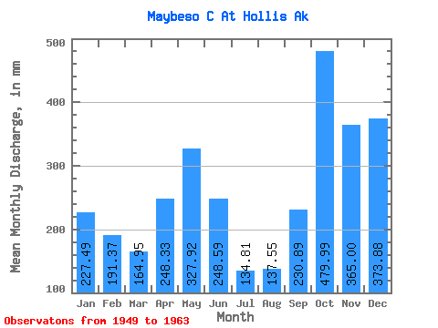
| Statistic | Jan | Feb | Mar | Apr | May | Jun | Jul | Aug | Sep | Oct | Nov | Dec | Annual |
|---|---|---|---|---|---|---|---|---|---|---|---|---|---|
| Mean | 227.48 | 193.03 | 164.95 | 248.34 | 327.88 | 248.60 | 134.80 | 137.56 | 230.87 | 479.93 | 364.98 | 373.84 | 3112.35 |
| Standard Deviation | 161.64 | 135.65 | 98.77 | 55.22 | 137.72 | 91.42 | 50.77 | 75.10 | 87.28 | 167.47 | 99.16 | 188.65 | 488.25 |
| Min | 23.29 | 17.66 | 58.22 | 161.00 | 95.41 | 58.82 | 36.09 | 37.53 | 93.30 | 176.24 | 203.05 | 77.51 | 2101.21 |
| Max | 522.53 | 541.74 | 412.30 | 341.27 | 598.66 | 383.69 | 215.06 | 268.65 | 366.67 | 798.48 | 529.80 | 667.55 | 3804.91 |
| Coefficient of Variation | 0.71 | 0.70 | 0.60 | 0.22 | 0.42 | 0.37 | 0.38 | 0.55 | 0.38 | 0.35 | 0.27 | 0.51 | 0.16 |
 Return to R-Arctic Net Home Page