|
|
|||||||||||||||||
| Point ID: 9306 | Downloads | Plots | Site Data | Code: 15085800 |
|
|
|||||||||||||||||
| Download | |
|---|---|
| Site Descriptor Information | Site Time Series Data |
| Link to all available data | |
|
|
| View: | Statistics | Time Series |
| Units: | m3/s |
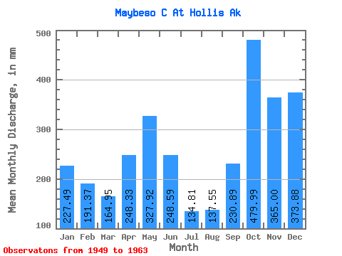
| Statistic | Jan | Feb | Mar | Apr | May | Jun | Jul | Aug | Sep | Oct | Nov | Dec | Annual |
|---|---|---|---|---|---|---|---|---|---|---|---|---|---|
| Mean | 227.48 | 193.03 | 164.95 | 248.34 | 327.88 | 248.60 | 134.80 | 137.56 | 230.87 | 479.93 | 364.98 | 373.84 | 3112.35 |
| Standard Deviation | 161.64 | 135.65 | 98.77 | 55.22 | 137.72 | 91.42 | 50.77 | 75.10 | 87.28 | 167.47 | 99.16 | 188.65 | 488.25 |
| Min | 23.29 | 17.66 | 58.22 | 161.00 | 95.41 | 58.82 | 36.09 | 37.53 | 93.30 | 176.24 | 203.05 | 77.51 | 2101.21 |
| Max | 522.53 | 541.74 | 412.30 | 341.27 | 598.66 | 383.69 | 215.06 | 268.65 | 366.67 | 798.48 | 529.80 | 667.55 | 3804.91 |
| Coefficient of Variation | 0.71 | 0.70 | 0.60 | 0.22 | 0.42 | 0.37 | 0.38 | 0.55 | 0.38 | 0.35 | 0.27 | 0.51 | 0.16 |
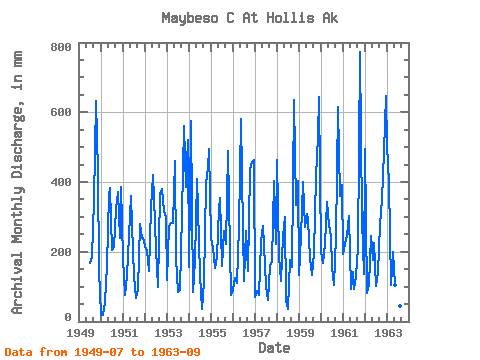
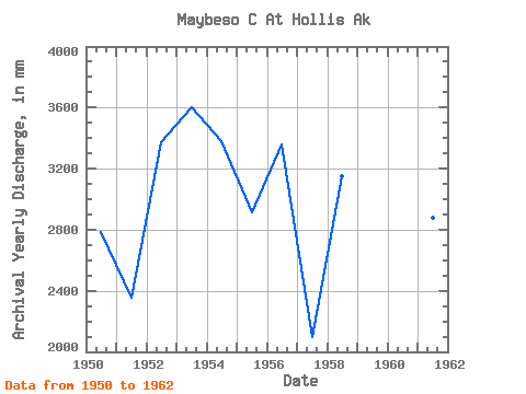
| Year | Jan | Feb | Mar | Apr | May | Jun | Jul | Aug | Sep | Oct | Nov | Dec | Annual | 1949 | 174.45 | 189.75 | 344.77 | 651.85 | 424.49 | 150.46 | 1950 | 23.29 | 17.66 | 58.22 | 161.00 | 375.69 | 383.69 | 210.47 | 222.03 | 323.49 | 383.76 | 239.47 | 398.21 | 2784.62 | 1951 | 186.07 | 70.70 | 135.75 | 248.79 | 370.75 | 277.19 | 133.35 | 68.95 | 93.30 | 290.30 | 238.34 | 248.25 | 2354.10 | 1952 | 222.60 | 190.84 | 149.65 | 326.56 | 432.81 | 353.84 | 215.06 | 100.85 | 366.67 | 391.27 | 315.93 | 310.00 | 3378.32 | 1953 | 122.01 | 257.50 | 291.67 | 281.77 | 474.79 | 182.40 | 87.87 | 93.34 | 311.05 | 578.27 | 385.07 | 537.92 | 3601.50 | 1954 | 162.48 | 541.74 | 85.96 | 173.51 | 422.11 | 323.00 | 136.50 | 37.53 | 112.44 | 408.09 | 440.51 | 511.20 | 3381.04 | 1955 | 248.19 | 198.86 | 158.29 | 185.90 | 332.59 | 353.54 | 165.82 | 267.77 | 221.57 | 504.26 | 203.05 | 77.51 | 2915.53 | 1956 | 94.79 | 118.09 | 115.18 | 270.88 | 598.66 | 260.18 | 119.86 | 268.65 | 144.36 | 449.96 | 457.53 | 477.35 | 3363.23 | 1957 | 71.44 | 82.17 | 79.33 | 227.70 | 284.04 | 215.82 | 106.57 | 63.69 | 158.30 | 176.24 | 402.84 | 230.04 | 2101.21 | 1958 | 476.99 | 175.96 | 119.12 | 245.40 | 308.18 | 58.82 | 36.09 | 180.93 | 156.87 | 656.35 | 334.83 | 416.86 | 3152.43 | 1959 | 138.76 | 230.49 | 412.30 | 269.64 | 318.95 | 291.34 | 188.69 | 136.71 | 197.48 | 431.25 | 529.80 | 663.73 | 3804.91 | 1960 | 205.46 | 157.88 | 229.98 | 341.27 | 285.67 | 245.22 | 160.88 | 108.11 | 241.53 | 636.76 | 360.67 | 403.85 | 3370.63 | 1961 | 199.70 | 210.41 | 256.39 | 301.29 | 95.41 | 140.86 | 97.26 | 134.32 | 211.11 | 798.48 | 292.34 | 140.90 | 2877.81 | 1962 | 510.45 | 75.86 | 107.86 | 243.97 | 182.43 | 225.76 | 104.11 | 146.26 | 277.14 | 362.24 | 484.87 | 667.55 | 3375.19 | 1963 | 522.53 | 374.25 | 109.54 | 199.10 | 108.23 | 168.69 | 85.07 | 44.53 | 303.03 |
|---|
 Return to R-Arctic Net Home Page