|
|
|||||||||||||||||
| Point ID: 9262 | Downloads | Plots | Site Data | Code: 15010000 |
|
|
|||||||||||||||||
| Download | |
|---|---|
| Site Descriptor Information | Site Time Series Data |
| Link to all available data | |
| View: | Time Series | All |
| Units: | m3/s |
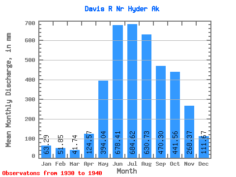
| Statistic | Jan | Feb | Mar | Apr | May | Jun | Jul | Aug | Sep | Oct | Nov | Dec | Annual |
|---|---|---|---|---|---|---|---|---|---|---|---|---|---|
| Mean | 63.28 | 52.30 | 41.73 | 124.57 | 393.98 | 678.41 | 684.51 | 630.64 | 470.30 | 441.49 | 268.37 | 111.65 | 3877.48 |
| Standard Deviation | 36.31 | 29.91 | 19.07 | 72.41 | 83.07 | 110.71 | 73.15 | 111.86 | 115.21 | 109.17 | 185.53 | 51.09 | 299.83 |
| Min | 16.29 | 10.30 | 16.55 | 36.60 | 233.09 | 513.72 | 626.31 | 546.27 | 315.72 | 324.15 | 70.53 | 51.38 | 3511.63 |
| Max | 138.30 | 93.45 | 73.76 | 286.85 | 556.53 | 839.18 | 884.27 | 911.54 | 643.64 | 677.47 | 566.18 | 191.87 | 4395.57 |
| Coefficient of Variation | 0.57 | 0.57 | 0.46 | 0.58 | 0.21 | 0.16 | 0.11 | 0.18 | 0.24 | 0.25 | 0.69 | 0.46 | 0.08 |
 Return to R-Arctic Net Home Page