|
|
|||||||||||||||||
| Point ID: 9262 | Downloads | Plots | Site Data | Code: 15010000 |
|
|
|||||||||||||||||
| Download | |
|---|---|
| Site Descriptor Information | Site Time Series Data |
| Link to all available data | |
|
|
| View: | Statistics | Time Series |
| Units: | m3/s |
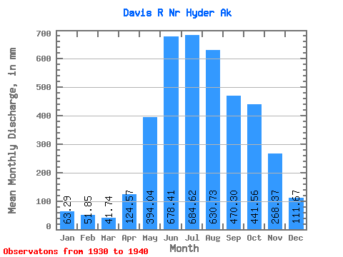
| Statistic | Jan | Feb | Mar | Apr | May | Jun | Jul | Aug | Sep | Oct | Nov | Dec | Annual |
|---|---|---|---|---|---|---|---|---|---|---|---|---|---|
| Mean | 63.28 | 52.30 | 41.73 | 124.57 | 393.98 | 678.41 | 684.51 | 630.64 | 470.30 | 441.49 | 268.37 | 111.65 | 3877.48 |
| Standard Deviation | 36.31 | 29.91 | 19.07 | 72.41 | 83.07 | 110.71 | 73.15 | 111.86 | 115.21 | 109.17 | 185.53 | 51.09 | 299.83 |
| Min | 16.29 | 10.30 | 16.55 | 36.60 | 233.09 | 513.72 | 626.31 | 546.27 | 315.72 | 324.15 | 70.53 | 51.38 | 3511.63 |
| Max | 138.30 | 93.45 | 73.76 | 286.85 | 556.53 | 839.18 | 884.27 | 911.54 | 643.64 | 677.47 | 566.18 | 191.87 | 4395.57 |
| Coefficient of Variation | 0.57 | 0.57 | 0.46 | 0.58 | 0.21 | 0.16 | 0.11 | 0.18 | 0.24 | 0.25 | 0.69 | 0.46 | 0.08 |
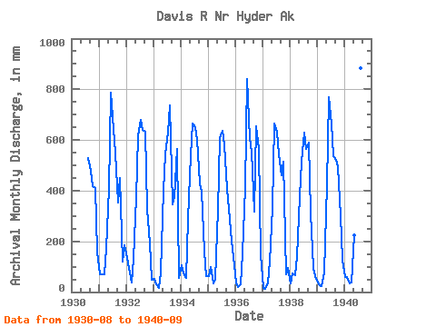
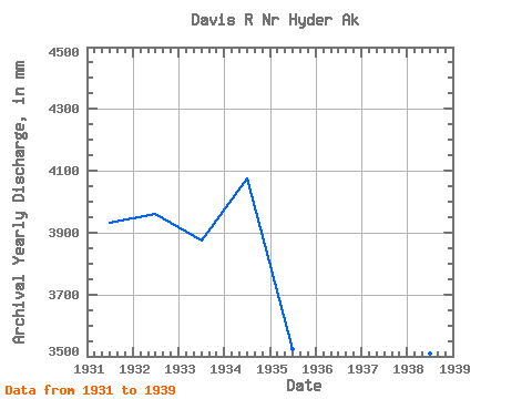
| Year | Jan | Feb | Mar | Apr | May | Jun | Jul | Aug | Sep | Oct | Nov | Dec | Annual | 1930 | 546.27 | 478.64 | 432.01 | 408.82 | 164.48 | 1931 | 71.18 | 67.18 | 73.76 | 173.79 | 421.42 | 785.34 | 663.14 | 568.18 | 351.41 | 464.85 | 121.22 | 191.87 | 3935.57 | 1932 | 138.30 | 88.06 | 39.89 | 131.55 | 385.60 | 614.30 | 701.17 | 661.85 | 631.54 | 339.93 | 192.68 | 51.38 | 3964.56 | 1933 | 52.33 | 28.32 | 16.55 | 75.59 | 414.42 | 545.17 | 650.99 | 759.60 | 345.10 | 388.15 | 563.60 | 56.40 | 3878.91 | 1934 | 108.54 | 68.88 | 57.76 | 286.85 | 556.53 | 664.19 | 670.93 | 620.17 | 429.53 | 407.65 | 160.25 | 64.08 | 4078.78 | 1935 | 66.62 | 93.45 | 36.30 | 52.51 | 334.94 | 607.16 | 656.06 | 600.16 | 405.98 | 340.35 | 201.32 | 143.53 | 3525.18 | 1936 | 40.35 | 17.45 | 30.14 | 152.39 | 422.49 | 839.18 | 626.31 | 572.59 | 315.72 | 677.47 | 566.18 | 151.65 | 4395.57 | 1937 | 16.29 | 10.30 | 34.57 | 120.94 | 343.86 | 665.75 | 654.40 | 562.67 | 460.09 | 531.48 | 70.53 | 97.40 | 3548.24 | 1938 | 36.94 | 68.08 | 69.77 | 136.88 | 391.82 | 513.72 | 651.22 | 582.04 | 590.29 | 324.15 | 94.56 | 65.31 | 3511.63 | 1939 | 39.47 | 24.69 | 24.71 | 78.57 | 435.64 | 768.22 | 686.64 | 551.92 | 521.35 | 508.88 | 304.56 | 130.44 | 4058.91 | 1940 | 62.78 | 56.56 | 33.87 | 36.60 | 233.09 | 781.09 | 884.27 | 911.54 | 643.64 |
|---|
 Return to R-Arctic Net Home Page