|
|
|||||||||||||||||
| Point ID: 9259 | Downloads | Plots | Site Data | Code: 15054000 |
|
|
|||||||||||||||||
| Download | |
|---|---|
| Site Descriptor Information | Site Time Series Data |
| Link to all available data | |
| View: | Time Series | All |
| Units: | m3/s |
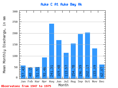
| Statistic | Jan | Feb | Mar | Apr | May | Jun | Jul | Aug | Sep | Oct | Nov | Dec | Annual |
|---|---|---|---|---|---|---|---|---|---|---|---|---|---|
| Mean | 57.44 | 48.53 | 51.43 | 93.50 | 241.31 | 169.55 | 113.51 | 154.71 | 196.47 | 202.08 | 133.07 | 62.00 | 1507.97 |
| Standard Deviation | 48.46 | 50.45 | 35.79 | 47.37 | 60.20 | 85.59 | 55.64 | 85.86 | 88.00 | 87.00 | 86.71 | 47.86 | 266.09 |
| Min | 7.00 | 4.61 | 14.34 | 20.98 | 139.46 | 50.65 | 47.64 | 31.32 | 68.28 | 111.08 | 27.50 | 21.89 | 1108.34 |
| Max | 146.58 | 199.31 | 125.53 | 195.01 | 348.82 | 319.94 | 243.85 | 372.38 | 386.29 | 433.26 | 308.02 | 201.01 | 2121.38 |
| Coefficient of Variation | 0.84 | 1.04 | 0.70 | 0.51 | 0.25 | 0.51 | 0.49 | 0.56 | 0.45 | 0.43 | 0.65 | 0.77 | 0.18 |
 Return to R-Arctic Net Home Page