|
|
|||||||||||||||||
| Point ID: 9259 | Downloads | Plots | Site Data | Code: 15054000 |
|
|
|||||||||||||||||
| Download | |
|---|---|
| Site Descriptor Information | Site Time Series Data |
| Link to all available data | |
|
|
| View: | Statistics | Time Series |
| Units: | m3/s |
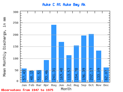
| Statistic | Jan | Feb | Mar | Apr | May | Jun | Jul | Aug | Sep | Oct | Nov | Dec | Annual |
|---|---|---|---|---|---|---|---|---|---|---|---|---|---|
| Mean | 57.44 | 48.53 | 51.43 | 93.50 | 241.31 | 169.55 | 113.51 | 154.71 | 196.47 | 202.08 | 133.07 | 62.00 | 1507.97 |
| Standard Deviation | 48.46 | 50.45 | 35.79 | 47.37 | 60.20 | 85.59 | 55.64 | 85.86 | 88.00 | 87.00 | 86.71 | 47.86 | 266.09 |
| Min | 7.00 | 4.61 | 14.34 | 20.98 | 139.46 | 50.65 | 47.64 | 31.32 | 68.28 | 111.08 | 27.50 | 21.89 | 1108.34 |
| Max | 146.58 | 199.31 | 125.53 | 195.01 | 348.82 | 319.94 | 243.85 | 372.38 | 386.29 | 433.26 | 308.02 | 201.01 | 2121.38 |
| Coefficient of Variation | 0.84 | 1.04 | 0.70 | 0.51 | 0.25 | 0.51 | 0.49 | 0.56 | 0.45 | 0.43 | 0.65 | 0.77 | 0.18 |
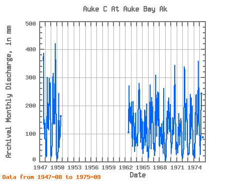
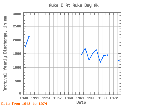
| Year | Jan | Feb | Mar | Apr | May | Jun | Jul | Aug | Sep | Oct | Nov | Dec | Annual | 1947 | 372.38 | 386.29 | 138.83 | 149.05 | 83.75 | 1948 | 141.78 | 20.52 | 17.64 | 20.98 | 310.95 | 118.84 | 184.88 | 116.80 | 297.12 | 206.29 | 279.77 | 21.89 | 1731.56 | 1949 | 18.28 | 23.70 | 82.73 | 195.01 | 298.93 | 314.06 | 137.25 | 146.30 | 135.58 | 433.26 | 308.02 | 33.04 | 2121.38 | 1950 | 13.13 | 9.85 | 14.99 | 50.89 | 251.69 | 50.65 | 108.41 | 90.95 | 162.56 | 1962 | 108.94 | 268.99 | 154.84 | 140.18 | 201.01 | 1963 | 139.16 | 199.31 | 116.63 | 54.76 | 220.90 | 132.41 | 123.34 | 37.19 | 102.21 | 177.82 | 57.25 | 90.00 | 1455.26 | 1964 | 68.92 | 88.91 | 58.26 | 141.84 | 237.78 | 278.51 | 243.85 | 147.49 | 68.28 | 188.20 | 122.07 | 46.66 | 1688.96 | 1965 | 146.58 | 28.50 | 67.83 | 97.67 | 189.82 | 178.06 | 60.77 | 81.87 | 116.40 | 212.17 | 37.07 | 56.33 | 1266.88 | 1966 | 15.61 | 14.45 | 82.39 | 153.28 | 282.93 | 149.86 | 47.64 | 236.38 | 196.89 | 198.52 | 84.31 | 44.71 | 1500.50 | 1967 | 67.01 | 26.46 | 23.71 | 51.61 | 317.55 | 170.07 | 93.99 | 208.71 | 247.72 | 133.06 | 244.67 | 59.50 | 1640.48 | 1968 | 56.25 | 115.70 | 125.53 | 63.35 | 139.46 | 62.36 | 69.53 | 31.32 | 261.52 | 117.64 | 93.05 | 39.10 | 1180.45 | 1969 | 7.00 | 4.61 | 22.66 | 133.63 | 186.51 | 101.36 | 209.60 | 233.73 | 122.02 | 111.08 | 203.45 | 109.79 | 1438.14 | 1970 | 30.34 | 63.15 | 66.42 | 69.23 | 162.77 | 96.03 | 108.67 | 204.92 | 343.68 | 216.60 | 60.64 | 26.23 | 1447.41 | 1971 | 71.15 | 52.95 | 33.33 | 73.61 | 176.18 | 125.62 | 62.06 | 122.45 | 152.68 | 140.07 | 75.81 | 23.31 | 1108.34 | 1972 | 19.38 | 12.16 | 40.51 | 48.43 | 348.82 | 319.94 | 79.57 | 214.60 | 185.30 | 230.79 | 78.42 | 24.98 | 1595.85 | 1973 | 24.84 | 28.04 | 28.91 | 99.97 | 247.46 | 128.88 | 84.20 | 234.52 | 124.32 | 205.04 | 27.50 | 22.41 | 1248.54 | 1974 | 18.76 | 58.38 | 14.34 | 117.71 | 239.23 | 239.49 | 98.88 | 105.97 | 151.43 | 369.05 | 167.91 | 109.35 | 1687.79 | 1975 | 80.81 | 29.86 | 27.01 | 124.11 | 250.04 | 246.63 | 103.52 | 90.32 | 213.52 |
|---|
 Return to R-Arctic Net Home Page