|
|
|||||||||||||||||
| Point ID: 9187 | Downloads | Plots | Site Data | Code: 15098000 |
|
|
|||||||||||||||||
| Download | |
|---|---|
| Site Descriptor Information | Site Time Series Data |
| Link to all available data | |
| View: | Time Series | All |
| Units: | m3/s |
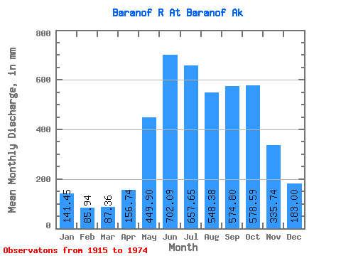
| Statistic | Jan | Feb | Mar | Apr | May | Jun | Jul | Aug | Sep | Oct | Nov | Dec | Annual |
|---|---|---|---|---|---|---|---|---|---|---|---|---|---|
| Mean | 141.44 | 86.68 | 87.37 | 156.74 | 449.84 | 702.08 | 657.54 | 548.31 | 574.81 | 578.51 | 335.74 | 182.99 | 4494.54 |
| Standard Deviation | 130.43 | 59.04 | 64.29 | 75.46 | 97.42 | 115.72 | 134.74 | 120.60 | 177.44 | 196.11 | 145.19 | 122.41 | 539.12 |
| Min | 33.08 | 29.17 | 27.12 | 62.89 | 288.06 | 439.97 | 403.51 | 283.54 | 261.89 | 316.74 | 67.79 | 50.31 | 3227.13 |
| Max | 679.39 | 284.09 | 286.64 | 382.43 | 682.70 | 926.93 | 945.83 | 832.21 | 929.11 | 1150.01 | 637.14 | 465.67 | 5347.45 |
| Coefficient of Variation | 0.92 | 0.68 | 0.74 | 0.48 | 0.22 | 0.17 | 0.20 | 0.22 | 0.31 | 0.34 | 0.43 | 0.67 | 0.12 |
 Return to R-Arctic Net Home Page