|
|
|||||||||||||||||
| Point ID: 9187 | Downloads | Plots | Site Data | Code: 15098000 |
|
|
|||||||||||||||||
| Download | |
|---|---|
| Site Descriptor Information | Site Time Series Data |
| Link to all available data | |
|
|
| View: | Statistics | Time Series |
| Units: | m3/s |
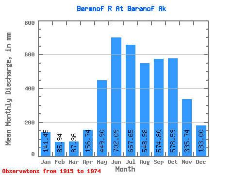
| Statistic | Jan | Feb | Mar | Apr | May | Jun | Jul | Aug | Sep | Oct | Nov | Dec | Annual |
|---|---|---|---|---|---|---|---|---|---|---|---|---|---|
| Mean | 141.44 | 86.68 | 87.37 | 156.74 | 449.84 | 702.08 | 657.54 | 548.31 | 574.81 | 578.51 | 335.74 | 182.99 | 4494.54 |
| Standard Deviation | 130.43 | 59.04 | 64.29 | 75.46 | 97.42 | 115.72 | 134.74 | 120.60 | 177.44 | 196.11 | 145.19 | 122.41 | 539.12 |
| Min | 33.08 | 29.17 | 27.12 | 62.89 | 288.06 | 439.97 | 403.51 | 283.54 | 261.89 | 316.74 | 67.79 | 50.31 | 3227.13 |
| Max | 679.39 | 284.09 | 286.64 | 382.43 | 682.70 | 926.93 | 945.83 | 832.21 | 929.11 | 1150.01 | 637.14 | 465.67 | 5347.45 |
| Coefficient of Variation | 0.92 | 0.68 | 0.74 | 0.48 | 0.22 | 0.17 | 0.20 | 0.22 | 0.31 | 0.34 | 0.43 | 0.67 | 0.12 |
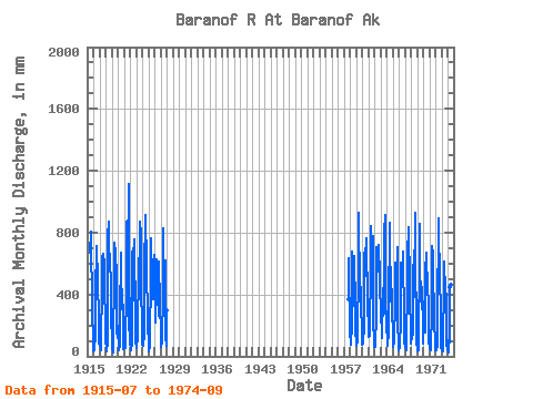
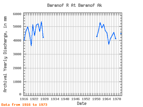
| Year | Jan | Feb | Mar | Apr | May | Jun | Jul | Aug | Sep | Oct | Nov | Dec | Annual | 1915 | 694.66 | 832.21 | 577.26 | 523.44 | 216.74 | 181.95 | 1916 | 36.77 | 46.13 | 38.66 | 142.78 | 411.79 | 711.87 | 615.46 | 553.69 | 599.90 | 479.39 | 266.03 | 90.94 | 3982.29 | 1917 | 71.52 | 75.34 | 43.32 | 88.24 | 461.18 | 636.79 | 662.26 | 681.47 | 659.28 | 624.89 | 587.50 | 82.44 | 4661.92 | 1918 | 117.71 | 55.00 | 35.14 | 88.33 | 398.27 | 778.63 | 896.50 | 706.87 | 638.83 | 617.46 | 486.51 | 191.81 | 4991.40 | 1919 | 256.13 | 50.01 | 27.46 | 185.52 | 448.40 | 574.40 | 756.27 | 685.76 | 669.40 | 526.13 | 162.53 | 125.85 | 4444.43 | 1920 | 206.88 | 82.25 | 41.84 | 67.17 | 289.80 | 636.70 | 695.05 | 531.74 | 360.70 | 316.86 | 336.14 | 50.31 | 3604.18 | 1921 | 73.18 | 100.01 | 58.19 | 126.32 | 396.29 | 870.64 | 667.14 | 525.15 | 642.63 | 1150.01 | 167.25 | 390.92 | 5143.58 | 1922 | 96.20 | 41.68 | 41.17 | 88.55 | 410.19 | 676.66 | 605.96 | 664.31 | 756.49 | 377.38 | 483.74 | 103.81 | 4337.58 | 1923 | 58.36 | 64.39 | 125.76 | 259.30 | 481.30 | 631.80 | 627.86 | 540.49 | 870.23 | 814.13 | 469.25 | 183.15 | 5113.00 | 1924 | 75.66 | 62.52 | 91.48 | 117.55 | 594.14 | 876.64 | 945.83 | 636.19 | 751.95 | 555.51 | 265.79 | 250.08 | 5201.25 | 1925 | 41.16 | 29.17 | 67.78 | 89.69 | 549.64 | 736.66 | 788.70 | 512.32 | 390.27 | 384.93 | 615.75 | 461.38 | 4646.27 | 1926 | 679.39 | 203.96 | 286.64 | 382.43 | 596.38 | 627.85 | 624.57 | 409.31 | 261.89 | 632.62 | 327.32 | 339.73 | 5347.45 | 1927 | 169.17 | 57.54 | 100.83 | 107.98 | 417.68 | 829.77 | 655.54 | 433.50 | 608.16 | 639.85 | 124.87 | 70.08 | 4199.39 | 1928 | 310.75 | 1957 | 384.19 | 637.14 | 127.39 | 1958 | 261.62 | 72.93 | 83.98 | 202.19 | 569.29 | 677.99 | 470.99 | 476.08 | 327.58 | 673.10 | 310.81 | 171.72 | 4277.72 | 1959 | 82.34 | 65.13 | 107.20 | 161.78 | 551.74 | 926.93 | 810.70 | 575.28 | 404.08 | 462.36 | 311.67 | 186.25 | 4627.26 | 1960 | 81.34 | 124.18 | 82.86 | 195.25 | 682.70 | 677.69 | 718.92 | 533.82 | 714.70 | 790.76 | 327.58 | 383.93 | 5292.80 | 1961 | 144.16 | 116.67 | 139.84 | 233.18 | 528.37 | 841.78 | 638.52 | 643.74 | 500.77 | 799.90 | 260.44 | 61.05 | 4891.46 | 1962 | 174.57 | 76.94 | 60.34 | 284.32 | 354.39 | 707.41 | 607.74 | 568.59 | 616.93 | 747.47 | 515.76 | 465.67 | 5163.88 | 1963 | 301.39 | 284.09 | 120.10 | 140.78 | 387.62 | 439.97 | 403.51 | 283.54 | 807.11 | 943.43 | 309.97 | 282.46 | 4702.16 | 1964 | 175.72 | 127.58 | 71.00 | 150.99 | 308.45 | 866.45 | 756.98 | 609.84 | 353.71 | 598.65 | 294.27 | 253.06 | 4551.32 | 1965 | 200.54 | 58.19 | 102.87 | 156.86 | 312.11 | 604.91 | 576.63 | 369.29 | 337.62 | 727.96 | 155.35 | 141.34 | 3723.02 | 1966 | 41.10 | 55.34 | 103.87 | 200.15 | 413.97 | 604.44 | 567.03 | 493.52 | 678.38 | 588.50 | 320.95 | 83.18 | 4140.11 | 1967 | 101.77 | 64.09 | 37.51 | 66.96 | 488.62 | 742.71 | 527.14 | 481.69 | 836.67 | 472.54 | 425.19 | 113.99 | 4354.37 | 1968 | 83.12 | 120.56 | 265.01 | 136.56 | 519.61 | 684.99 | 488.21 | 398.71 | 929.11 | 491.10 | 347.18 | 105.14 | 4567.30 | 1969 | 33.08 | 33.58 | 40.28 | 267.20 | 476.49 | 853.67 | 571.04 | 423.85 | 399.10 | 316.74 | 449.65 | 270.44 | 4128.41 | 1970 | 87.55 | 213.99 | 176.25 | 153.52 | 397.88 | 549.73 | 695.83 | 476.44 | 540.87 | 436.75 | 362.70 | 87.43 | 4176.89 | 1971 | 156.87 | 59.38 | 41.43 | 70.21 | 288.06 | 700.92 | 739.18 | 677.17 | 474.26 | 340.72 | 243.71 | 78.37 | 3855.11 | 1972 | 43.08 | 37.65 | 78.82 | 62.89 | 451.71 | 697.91 | 920.63 | 719.55 | 626.78 | 598.89 | 222.64 | 59.72 | 4495.32 | 1973 | 44.29 | 34.35 | 36.89 | 178.26 | 397.18 | 614.15 | 411.94 | 528.19 | 489.31 | 339.61 | 67.79 | 95.96 | 3227.13 | 1974 | 37.77 | 101.03 | 27.12 | 140.51 | 462.15 | 580.21 | 585.54 | 476.88 | 420.29 |
|---|
 Return to R-Arctic Net Home Page