|
|
|||||||||||||||||
| Point ID: 9159 | Downloads | Plots | Site Data | Code: 15109000 |
|
|
|||||||||||||||||
| Download | |
|---|---|
| Site Descriptor Information | Site Time Series Data |
| Link to all available data | |
| View: | Time Series | All |
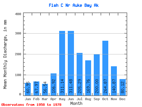
| Units: | m3/s |
| Statistic | Jan | Feb | Mar | Apr | May | Jun | Jul | Aug | Sep | Oct | Nov | Dec | Annual |
|---|---|---|---|---|---|---|---|---|---|---|---|---|---|
| Mean | 60.93 | 68.54 | 56.54 | 106.93 | 311.06 | 311.45 | 205.24 | 169.71 | 200.01 | 264.87 | 140.86 | 80.14 | 1986.62 |
| Standard Deviation | 44.44 | 63.64 | 32.20 | 38.79 | 61.64 | 89.23 | 62.81 | 77.33 | 78.83 | 86.92 | 74.22 | 57.53 | 227.01 |
| Min | 5.81 | 8.40 | 8.12 | 41.48 | 202.52 | 154.02 | 105.98 | 47.39 | 83.89 | 102.81 | 31.84 | 16.73 | 1476.78 |
| Max | 142.33 | 217.03 | 126.62 | 210.96 | 437.26 | 486.75 | 360.16 | 347.96 | 366.70 | 494.73 | 291.23 | 215.50 | 2305.08 |
| Coefficient of Variation | 0.73 | 0.93 | 0.57 | 0.36 | 0.20 | 0.29 | 0.31 | 0.46 | 0.39 | 0.33 | 0.53 | 0.72 | 0.11 |
 Return to R-Arctic Net Home Page