|
|
|||||||||||||||||
| Point ID: 9159 | Downloads | Plots | Site Data | Code: 15109000 |
|
|
|||||||||||||||||
| Download | |
|---|---|
| Site Descriptor Information | Site Time Series Data |
| Link to all available data | |
|
|
| View: | Statistics | Time Series |
| Units: | m3/s |
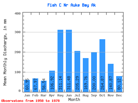
| Statistic | Jan | Feb | Mar | Apr | May | Jun | Jul | Aug | Sep | Oct | Nov | Dec | Annual |
|---|---|---|---|---|---|---|---|---|---|---|---|---|---|
| Mean | 60.93 | 68.54 | 56.54 | 106.93 | 311.06 | 311.45 | 205.24 | 169.71 | 200.01 | 264.87 | 140.86 | 80.14 | 1986.62 |
| Standard Deviation | 44.44 | 63.64 | 32.20 | 38.79 | 61.64 | 89.23 | 62.81 | 77.33 | 78.83 | 86.92 | 74.22 | 57.53 | 227.01 |
| Min | 5.81 | 8.40 | 8.12 | 41.48 | 202.52 | 154.02 | 105.98 | 47.39 | 83.89 | 102.81 | 31.84 | 16.73 | 1476.78 |
| Max | 142.33 | 217.03 | 126.62 | 210.96 | 437.26 | 486.75 | 360.16 | 347.96 | 366.70 | 494.73 | 291.23 | 215.50 | 2305.08 |
| Coefficient of Variation | 0.73 | 0.93 | 0.57 | 0.36 | 0.20 | 0.29 | 0.31 | 0.46 | 0.39 | 0.33 | 0.53 | 0.72 | 0.11 |
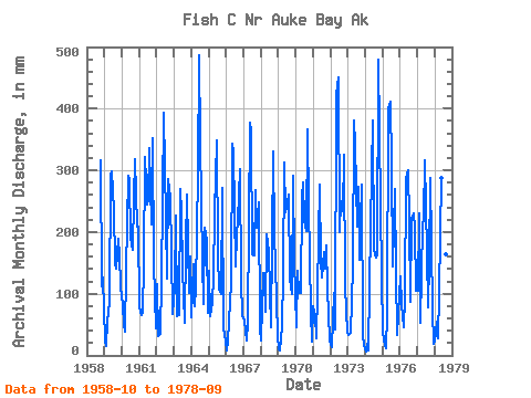
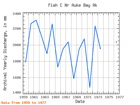
| Year | Jan | Feb | Mar | Apr | May | Jun | Jul | Aug | Sep | Oct | Nov | Dec | Annual | 1958 | 326.06 | 111.34 | 130.25 | 1959 | 25.87 | 13.72 | 56.52 | 86.32 | 303.62 | 299.22 | 243.61 | 155.46 | 141.02 | 194.93 | 162.86 | 115.23 | 1789.89 | 1960 | 84.43 | 46.23 | 40.23 | 137.62 | 300.07 | 283.30 | 197.12 | 177.00 | 252.71 | 328.91 | 209.07 | 215.50 | 2264.70 | 1961 | 79.74 | 62.33 | 72.62 | 147.14 | 332.04 | 243.96 | 259.96 | 347.96 | 212.00 | 364.50 | 149.09 | 44.75 | 2305.08 | 1962 | 118.98 | 29.87 | 35.58 | 123.03 | 262.62 | 392.99 | 227.10 | 129.55 | 285.87 | 264.22 | 165.15 | 69.22 | 2100.85 | 1963 | 116.33 | 213.05 | 66.53 | 65.40 | 279.16 | 232.43 | 145.69 | 53.93 | 178.77 | 269.01 | 102.04 | 164.91 | 1892.72 | 1964 | 63.24 | 139.16 | 83.19 | 110.51 | 304.10 | 486.75 | 360.16 | 156.01 | 83.89 | 214.32 | 186.55 | 70.74 | 2259.72 | 1965 | 142.33 | 59.59 | 89.51 | 126.78 | 239.97 | 348.91 | 167.30 | 112.52 | 99.46 | 279.65 | 43.92 | 24.85 | 1729.53 | 1966 | 8.31 | 20.65 | 58.04 | 117.53 | 353.86 | 328.76 | 149.50 | 202.93 | 219.42 | 312.73 | 119.06 | 67.82 | 1951.04 | 1967 | 57.58 | 38.27 | 24.70 | 52.71 | 390.14 | 365.04 | 170.27 | 167.28 | 267.60 | 214.81 | 247.99 | 45.31 | 2039.17 | 1968 | 24.36 | 125.25 | 126.62 | 70.26 | 202.52 | 167.37 | 105.98 | 47.39 | 330.15 | 200.22 | 147.91 | 31.65 | 1586.68 | 1969 | 9.99 | 8.40 | 49.02 | 129.22 | 322.52 | 232.56 | 255.55 | 270.19 | 124.48 | 102.81 | 291.23 | 157.96 | 1945.03 | 1970 | 46.82 | 128.22 | 104.24 | 100.57 | 264.50 | 281.29 | 227.71 | 207.79 | 366.70 | 251.71 | 71.44 | 23.03 | 2075.87 | 1971 | 82.39 | 60.75 | 29.18 | 104.95 | 285.70 | 154.02 | 129.94 | 174.02 | 140.47 | 183.33 | 108.70 | 27.48 | 1476.78 | 1972 | 16.72 | 12.55 | 105.38 | 41.48 | 437.26 | 450.12 | 206.78 | 259.00 | 233.40 | 336.14 | 111.20 | 37.94 | 2236.16 | 1973 | 33.71 | 33.37 | 37.46 | 141.93 | 394.04 | 341.68 | 215.61 | 282.22 | 155.21 | 285.28 | 31.84 | 16.73 | 1958.85 | 1974 | 5.81 | 18.24 | 8.12 | 112.19 | 310.99 | 380.60 | 175.97 | 163.24 | 161.80 | 494.73 | 245.28 | 131.07 | 2199.53 | 1975 | 39.48 | 14.48 | 12.93 | 66.02 | 413.78 | 411.55 | 317.33 | 148.38 | 269.89 | 139.06 | 32.65 | 101.20 | 1958.29 | 1976 | 132.11 | 78.92 | 47.37 | 92.10 | 297.23 | 300.54 | 226.87 | 90.62 | 220.68 | 237.12 | 207.62 | 107.92 | 2036.88 | 1977 | 107.94 | 217.03 | 54.14 | 210.96 | 230.16 | 315.62 | 171.03 | 79.71 | 152.31 | 297.79 | 72.28 | 19.28 | 1938.94 | 1978 | 22.51 | 50.75 | 29.32 | 101.82 | 297.02 | 212.26 | 151.40 | 169.00 | 104.28 |
|---|
 Return to R-Arctic Net Home Page