|
|
|||||||||||||||||
| Point ID: 9143 | Downloads | Plots | Site Data | Code: 15106920 |
|
|
|||||||||||||||||
| Download | |
|---|---|
| Site Descriptor Information | Site Time Series Data |
| Link to all available data | |
| View: | Time Series | All |
| Units: | m3/s |
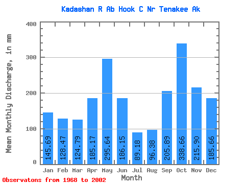
| Statistic | Jan | Feb | Mar | Apr | May | Jun | Jul | Aug | Sep | Oct | Nov | Dec | Annual |
|---|---|---|---|---|---|---|---|---|---|---|---|---|---|
| Mean | 145.69 | 129.59 | 124.82 | 185.16 | 295.58 | 186.15 | 89.19 | 96.41 | 205.87 | 338.62 | 215.86 | 185.66 | 2244.08 |
| Standard Deviation | 100.34 | 82.95 | 79.10 | 66.89 | 97.68 | 97.88 | 42.91 | 50.80 | 83.69 | 115.85 | 101.69 | 111.78 | 315.04 |
| Min | 17.69 | 15.58 | 26.44 | 63.19 | 120.64 | 55.14 | 18.46 | 27.11 | 48.60 | 145.47 | 49.25 | 23.13 | 1802.66 |
| Max | 422.71 | 308.54 | 371.20 | 327.89 | 523.34 | 418.88 | 172.95 | 226.92 | 392.39 | 672.79 | 422.58 | 422.43 | 3025.54 |
| Coefficient of Variation | 0.69 | 0.64 | 0.63 | 0.36 | 0.33 | 0.53 | 0.48 | 0.53 | 0.41 | 0.34 | 0.47 | 0.60 | 0.14 |
 Return to R-Arctic Net Home Page