|
|
|||||||||||||||||
| Point ID: 9143 | Downloads | Plots | Site Data | Code: 15106920 |
|
|
|||||||||||||||||
| Download | |
|---|---|
| Site Descriptor Information | Site Time Series Data |
| Link to all available data | |
|
|
| View: | Statistics | Time Series |
| Units: | m3/s |
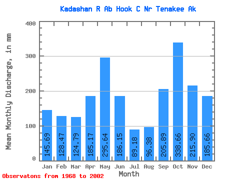
| Statistic | Jan | Feb | Mar | Apr | May | Jun | Jul | Aug | Sep | Oct | Nov | Dec | Annual |
|---|---|---|---|---|---|---|---|---|---|---|---|---|---|
| Mean | 145.69 | 129.59 | 124.82 | 185.16 | 295.58 | 186.15 | 89.19 | 96.41 | 205.87 | 338.62 | 215.86 | 185.66 | 2244.08 |
| Standard Deviation | 100.34 | 82.95 | 79.10 | 66.89 | 97.68 | 97.88 | 42.91 | 50.80 | 83.69 | 115.85 | 101.69 | 111.78 | 315.04 |
| Min | 17.69 | 15.58 | 26.44 | 63.19 | 120.64 | 55.14 | 18.46 | 27.11 | 48.60 | 145.47 | 49.25 | 23.13 | 1802.66 |
| Max | 422.71 | 308.54 | 371.20 | 327.89 | 523.34 | 418.88 | 172.95 | 226.92 | 392.39 | 672.79 | 422.58 | 422.43 | 3025.54 |
| Coefficient of Variation | 0.69 | 0.64 | 0.63 | 0.36 | 0.33 | 0.53 | 0.48 | 0.53 | 0.41 | 0.34 | 0.47 | 0.60 | 0.14 |
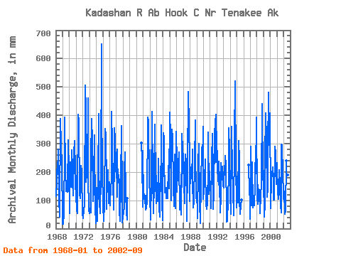
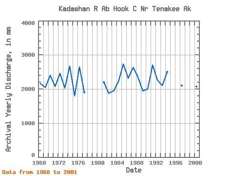
| Year | Jan | Feb | Mar | Apr | May | Jun | Jul | Aug | Sep | Oct | Nov | Dec | Annual | 1968 | 118.78 | 160.37 | 216.83 | 192.30 | 289.48 | 106.30 | 42.40 | 58.53 | 388.21 | 307.45 | 222.69 | 44.41 | 2154.28 | 1969 | 17.69 | 15.58 | 53.61 | 282.08 | 406.41 | 208.32 | 136.34 | 137.22 | 129.84 | 145.47 | 312.96 | 210.15 | 2050.70 | 1970 | 56.57 | 221.62 | 188.94 | 146.33 | 287.16 | 214.25 | 172.95 | 120.00 | 267.55 | 320.61 | 140.12 | 265.47 | 2404.82 | 1971 | 123.05 | 63.37 | 56.63 | 116.22 | 415.57 | 376.82 | 126.60 | 109.71 | 212.40 | 228.13 | 202.40 | 47.18 | 2076.47 | 1972 | 52.45 | 35.19 | 71.44 | 78.49 | 523.34 | 418.88 | 168.69 | 195.51 | 205.46 | 474.89 | 181.55 | 68.48 | 2462.15 | 1973 | 55.50 | 66.65 | 58.94 | 249.76 | 401.40 | 307.86 | 100.12 | 143.81 | 180.71 | 340.34 | 49.25 | 84.33 | 2034.14 | 1974 | 19.40 | 135.45 | 26.44 | 180.60 | 417.72 | 240.12 | 98.09 | 56.85 | 185.22 | 672.79 | 422.58 | 219.14 | 2672.92 | 1975 | 81.08 | 29.02 | 28.51 | 87.49 | 365.45 | 327.32 | 164.43 | 70.60 | 184.23 | 214.14 | 87.95 | 169.75 | 1802.66 | 1976 | 113.97 | 77.42 | 158.26 | 163.11 | 426.97 | 292.29 | 172.85 | 69.58 | 262.27 | 366.93 | 316.20 | 228.21 | 2641.66 | 1977 | 184.31 | 264.15 | 114.63 | 210.56 | 177.63 | 174.31 | 63.40 | 27.11 | 159.88 | 374.38 | 111.11 | 23.13 | 1897.47 | 1978 | 41.72 | 55.30 | 79.78 | 201.56 | 279.10 | 123.91 | 61.17 | 32.72 | 107.72 | 1980 | 311.15 | 241.14 | 79.79 | 1981 | 282.98 | 97.68 | 126.02 | 89.43 | 120.64 | 66.63 | 75.27 | 100.44 | 392.39 | 293.17 | 385.25 | 176.06 | 2206.18 | 1982 | 121.47 | 28.61 | 50.86 | 144.56 | 425.38 | 183.02 | 64.31 | 55.43 | 161.90 | 378.89 | 169.87 | 91.24 | 1866.21 | 1983 | 192.64 | 108.52 | 100.34 | 228.62 | 254.26 | 70.44 | 41.49 | 226.92 | 220.10 | 377.22 | 95.35 | 29.66 | 1941.14 | 1984 | 347.75 | 302.23 | 258.43 | 125.95 | 148.44 | 144.39 | 111.28 | 130.56 | 106.20 | 230.07 | 142.63 | 157.61 | 2211.88 | 1985 | 422.71 | 308.54 | 102.94 | 156.34 | 361.38 | 320.19 | 153.78 | 82.73 | 128.26 | 269.74 | 71.08 | 354.69 | 2734.96 | 1986 | 242.12 | 121.98 | 255.83 | 168.20 | 279.18 | 239.29 | 68.37 | 94.60 | 48.60 | 347.20 | 146.15 | 317.00 | 2318.11 | 1987 | 231.83 | 152.63 | 92.74 | 210.09 | 270.28 | 232.52 | 69.39 | 27.18 | 224.92 | 498.34 | 364.57 | 251.02 | 2626.72 | 1988 | 100.54 | 205.40 | 190.32 | 178.03 | 288.18 | 170.24 | 76.48 | 100.63 | 234.75 | 395.85 | 294.80 | 109.50 | 2350.94 | 1989 | 134.70 | 46.07 | 37.81 | 225.38 | 309.21 | 95.91 | 18.46 | 31.47 | 154.02 | 295.86 | 232.06 | 372.39 | 1945.76 | 1990 | 108.59 | 127.49 | 174.66 | 245.50 | 212.56 | 83.41 | 72.12 | 94.67 | 210.92 | 350.25 | 121.69 | 207.65 | 2007.22 | 1991 | 139.18 | 154.70 | 73.38 | 239.75 | 345.43 | 191.55 | 71.92 | 128.61 | 329.09 | 387.32 | 401.93 | 241.18 | 2708.25 | 1992 | 354.06 | 197.01 | 182.17 | 154.95 | 244.80 | 164.68 | 58.84 | 118.33 | 231.31 | 178.83 | 218.99 | 153.07 | 2260.55 | 1993 | 149.46 | 188.72 | 196.81 | 257.63 | 231.93 | 67.19 | 25.46 | 27.13 | 103.08 | 203.39 | 355.31 | 285.48 | 2097.72 | 1994 | 128.05 | 49.14 | 371.20 | 327.89 | 238.32 | 122.79 | 61.07 | 49.11 | 316.85 | 537.80 | 210.65 | 96.36 | 2500.82 | 1995 | 76.63 | 172.92 | 93.76 | 310.92 | 250.46 | 101.39 | 53.56 | 85.33 | 101.68 | 1996 | 231.28 | 128.44 | 110.78 | 1997 | 35.02 | 273.12 | 84.69 | 215.93 | 242.03 | 74.32 | 93.63 | 84.68 | 150.68 | 239.43 | 195.55 | 405.76 | 2104.15 | 1998 | 103.50 | 145.16 | 88.85 | 140.40 | 139.26 | 55.14 | 66.34 | 116.38 | 161.62 | 454.12 | 171.44 | 239.79 | 1879.37 | 1999 | 182.26 | 38.87 | 90.99 | 242.53 | 420.87 | 312.67 | 114.83 | 148.07 | 274.40 | 495.72 | 296.00 | 422.43 | 3025.54 | 2000 | 95.07 | 66.69 | 181.52 | 188.22 | 223.97 | 174.60 | 104.89 | 106.02 | 288.97 | 273.89 | 209.63 | 161.32 | 2072.04 | 2001 | 240.54 | 113.28 | 134.08 | 102.95 | 213.85 | 150.88 | 83.89 | 59.54 | 298.13 | 302.72 | 192.20 | 132.59 | 2023.43 | 2002 | 108.50 | 124.12 | 52.83 | 63.19 | 247.87 | 145.04 | 61.57 | 195.66 | 166.35 |
|---|
 Return to R-Arctic Net Home Page