|
|
|||||||||||||||||
| Point ID: 9036 | Downloads | Plots | Site Data | Code: 71267 |
|
|
|||||||||||||||||
| Download | |
|---|---|
| Site Descriptor Information | Site Time Series Data |
| Link to all available data | |
| View: | Time Series | All |
| Units: | m3/s |
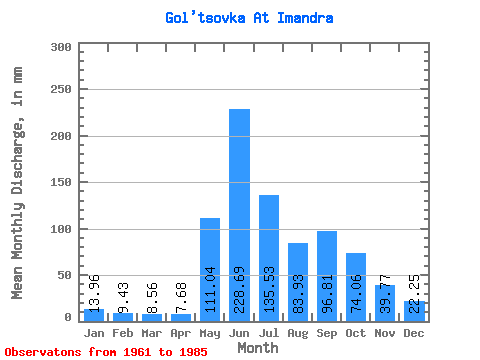
| Statistic | Jan | Feb | Mar | Apr | May | Jun | Jul | Aug | Sep | Oct | Nov | Dec | Annual |
|---|---|---|---|---|---|---|---|---|---|---|---|---|---|
| Mean | 13.97 | 9.52 | 8.55 | 7.67 | 111.04 | 228.68 | 135.51 | 83.93 | 96.81 | 74.06 | 39.76 | 22.24 | 830.07 |
| Standard Deviation | 2.85 | 1.62 | 1.49 | 2.81 | 77.00 | 66.54 | 71.31 | 31.80 | 26.74 | 27.79 | 18.53 | 5.13 | 152.27 |
| Min | 9.54 | 5.43 | 5.96 | 3.17 | 13.72 | 101.60 | 53.08 | 38.17 | 43.59 | 36.38 | 21.36 | 13.42 | 566.71 |
| Max | 20.28 | 12.77 | 12.23 | 17.32 | 277.34 | 398.32 | 331.02 | 159.84 | 168.28 | 134.79 | 109.97 | 35.19 | 1195.80 |
| Coefficient of Variation | 0.20 | 0.17 | 0.17 | 0.37 | 0.69 | 0.29 | 0.53 | 0.38 | 0.28 | 0.38 | 0.47 | 0.23 | 0.18 |
 Return to R-Arctic Net Home Page