|
|
|||||||||||||||||
| Point ID: 9036 | Downloads | Plots | Site Data | Code: 71267 |
|
|
|||||||||||||||||
| Download | |
|---|---|
| Site Descriptor Information | Site Time Series Data |
| Link to all available data | |
| View: | Time Series | All |
| Units: | mm |
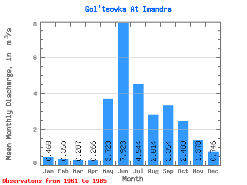
| Statistic | Jan | Feb | Mar | Apr | May | Jun | Jul | Aug | Sep | Oct | Nov | Dec | Annual |
|---|---|---|---|---|---|---|---|---|---|---|---|---|---|
| Mean | 0.47 | 0.35 | 0.29 | 0.27 | 3.72 | 7.92 | 4.54 | 2.81 | 3.35 | 2.48 | 1.38 | 0.75 | 2.36 |
| Standard Deviation | 0.10 | 0.06 | 0.05 | 0.10 | 2.58 | 2.31 | 2.39 | 1.07 | 0.93 | 0.93 | 0.64 | 0.17 | 0.43 |
| Min | 0.32 | 0.20 | 0.20 | 0.11 | 0.46 | 3.52 | 1.78 | 1.28 | 1.51 | 1.22 | 0.74 | 0.45 | 1.61 |
| Max | 0.68 | 0.47 | 0.41 | 0.60 | 9.30 | 13.80 | 11.10 | 5.36 | 5.83 | 4.52 | 3.81 | 1.18 | 3.40 |
| Coefficient of Variation | 0.20 | 0.17 | 0.17 | 0.37 | 0.69 | 0.29 | 0.53 | 0.38 | 0.28 | 0.38 | 0.47 | 0.23 | 0.18 |
 Return to R-Arctic Net Home Page