|
|
|||||||||||||||||
| Point ID: 9027 | Downloads | Plots | Site Data | Code: 71232 |
|
|
|||||||||||||||||
| Download | |
|---|---|
| Site Descriptor Information | Site Time Series Data |
| Link to all available data | |
| View: | Time Series | All |
| Units: | m3/s |
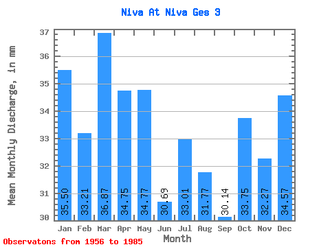
| Statistic | Jan | Feb | Mar | Apr | May | Jun | Jul | Aug | Sep | Oct | Nov | Dec | Annual |
|---|---|---|---|---|---|---|---|---|---|---|---|---|---|
| Mean | 35.50 | 33.49 | 36.86 | 34.75 | 34.77 | 30.69 | 33.00 | 31.77 | 30.14 | 33.74 | 32.27 | 34.56 | 401.71 |
| Standard Deviation | 5.80 | 6.33 | 6.79 | 6.65 | 7.87 | 10.83 | 16.59 | 10.57 | 8.00 | 6.56 | 6.27 | 6.76 | 61.16 |
| Min | 11.55 | 7.78 | 8.96 | 16.83 | 16.86 | 15.47 | 15.98 | 18.37 | 2.51 | 15.38 | 16.42 | 13.93 | 216.15 |
| Max | 49.17 | 44.61 | 49.38 | 47.38 | 56.28 | 66.83 | 106.49 | 70.72 | 47.79 | 47.07 | 44.15 | 48.75 | 524.97 |
| Coefficient of Variation | 0.16 | 0.19 | 0.18 | 0.19 | 0.23 | 0.35 | 0.50 | 0.33 | 0.27 | 0.20 | 0.19 | 0.20 | 0.15 |
 Return to R-Arctic Net Home Page