|
|
|||||||||||||||||
| Point ID: 9027 | Downloads | Plots | Site Data | Code: 71232 |
|
|
|||||||||||||||||
| Download | |
|---|---|
| Site Descriptor Information | Site Time Series Data |
| Link to all available data | |
| View: | Time Series | All |
| Units: | mm |
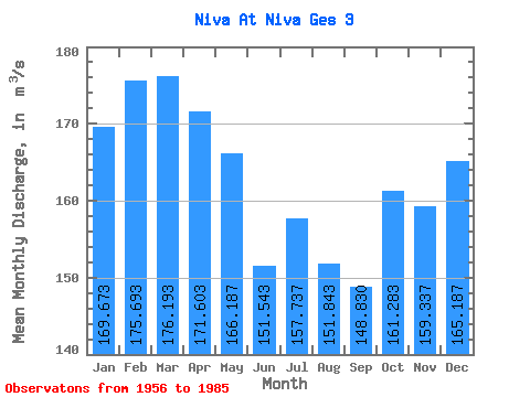
| Statistic | Jan | Feb | Mar | Apr | May | Jun | Jul | Aug | Sep | Oct | Nov | Dec | Annual |
|---|---|---|---|---|---|---|---|---|---|---|---|---|---|
| Mean | 169.67 | 175.69 | 176.19 | 171.60 | 166.19 | 151.54 | 157.74 | 151.84 | 148.83 | 161.28 | 159.34 | 165.19 | 162.93 |
| Standard Deviation | 27.72 | 33.23 | 32.48 | 32.83 | 37.63 | 53.48 | 79.28 | 50.51 | 39.48 | 31.38 | 30.98 | 32.33 | 24.80 |
| Min | 55.20 | 40.80 | 42.80 | 83.10 | 80.60 | 76.40 | 76.40 | 87.80 | 12.40 | 73.50 | 81.10 | 66.60 | 87.67 |
| Max | 235.00 | 234.00 | 236.00 | 234.00 | 269.00 | 330.00 | 509.00 | 338.00 | 236.00 | 225.00 | 218.00 | 233.00 | 212.92 |
| Coefficient of Variation | 0.16 | 0.19 | 0.18 | 0.19 | 0.23 | 0.35 | 0.50 | 0.33 | 0.27 | 0.20 | 0.19 | 0.20 | 0.15 |
 Return to R-Arctic Net Home Page