|
|
|||||||||||||||||
| Point ID: 8935 | Downloads | Plots | Site Data | Code: 70607 |
|
|
|||||||||||||||||
| Download | |
|---|---|
| Site Descriptor Information | Site Time Series Data |
| Link to all available data | |
| View: | Time Series | All |
| Units: | m3/s |
| Statistic | Jan | Feb | Mar | Apr | May | Jun | Jul | Aug | Sep | Oct | Nov | Dec | Annual |
|---|---|---|---|---|---|---|---|---|---|---|---|---|---|
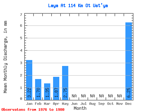
| Mean | 3.22 | 1.72 | 1.35 | 1.87 | 2.75 | 6.25 | |||||||
| Standard Deviation | 1.81 | 0.77 | 0.56 | 0.26 | 2.53 | ||||||||
| Min | 1.13 | 0.72 | 0.57 | 1.69 | 2.75 | 4.46 | |||||||
| Max | 4.33 | 2.47 | 2.04 | 2.06 | 2.75 | 8.04 | |||||||
| Coefficient of Variation | 0.56 | 0.45 | 0.41 | 0.14 | 0.41 |
 Return to R-Arctic Net Home Page