|
|
| Point ID: 8935 | Downloads | Plots | Site Data | Code: 70607 |
|
| Download | |
|---|---|
| Site Descriptor Information | Site Time Series Data |
| Link to all available data | |
|
|
|
| View: | Statistics | All |
| Units: | m3/s |
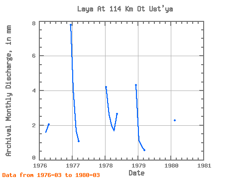
| Year | Jan | Feb | Mar | Apr | May | Jun | Jul | Aug | Sep | Oct | Nov | Dec | Annual | 1976 | 1.65 | 2.06 | 8.04 | 1977 | 4.19 | 1.55 | 1.11 | 1978 | 4.33 | 2.47 | 2.04 | 1.69 | 2.75 | 4.46 | 1979 | 1.13 | 0.72 | 0.57 | 1980 | 2.14 | 1.39 |
|---|
 Return to R-Arctic Net Home Page