|
|
|||||||||||||||||
| Point ID: 8914 | Downloads | Plots | Site Data | Code: 70578 |
|
|
|||||||||||||||||
| Download | |
|---|---|
| Site Descriptor Information | Site Time Series Data |
| Link to all available data | |
| View: | Time Series | All |
| Units: | m3/s |
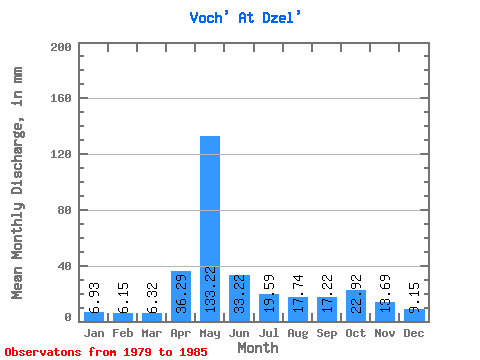
| Statistic | Jan | Feb | Mar | Apr | May | Jun | Jul | Aug | Sep | Oct | Nov | Dec | Annual |
|---|---|---|---|---|---|---|---|---|---|---|---|---|---|
| Mean | 6.93 | 6.20 | 6.32 | 36.29 | 133.20 | 33.22 | 19.59 | 17.74 | 17.22 | 22.91 | 13.69 | 9.15 | 318.47 |
| Standard Deviation | 3.20 | 2.78 | 2.59 | 55.23 | 47.16 | 12.81 | 9.20 | 16.16 | 10.01 | 8.80 | 3.63 | 4.25 | |
| Min | 3.58 | 3.27 | 2.64 | 5.29 | 41.30 | 16.79 | 9.62 | 7.45 | 6.75 | 9.90 | 9.40 | 5.28 | 318.47 |
| Max | 9.71 | 10.48 | 9.24 | 156.98 | 188.59 | 54.30 | 36.68 | 52.05 | 36.33 | 32.91 | 18.25 | 13.86 | 318.47 |
| Coefficient of Variation | 0.46 | 0.45 | 0.41 | 1.52 | 0.35 | 0.39 | 0.47 | 0.91 | 0.58 | 0.38 | 0.27 | 0.46 |
 Return to R-Arctic Net Home Page