|
|
|||||||||||||||||
| Point ID: 8914 | Downloads | Plots | Site Data | Code: 70578 |
|
|
|||||||||||||||||
| Download | |
|---|---|
| Site Descriptor Information | Site Time Series Data |
| Link to all available data | |
| View: | Time Series | All |
| Units: | mm |
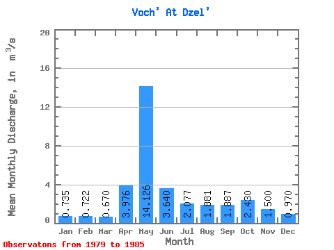
| Statistic | Jan | Feb | Mar | Apr | May | Jun | Jul | Aug | Sep | Oct | Nov | Dec | Annual |
|---|---|---|---|---|---|---|---|---|---|---|---|---|---|
| Mean | 0.73 | 0.72 | 0.67 | 3.98 | 14.13 | 3.64 | 2.08 | 1.88 | 1.89 | 2.43 | 1.50 | 0.97 | 2.87 |
| Standard Deviation | 0.34 | 0.32 | 0.27 | 6.05 | 5.00 | 1.40 | 0.97 | 1.71 | 1.10 | 0.93 | 0.40 | 0.45 | |
| Min | 0.38 | 0.38 | 0.28 | 0.58 | 4.38 | 1.84 | 1.02 | 0.79 | 0.74 | 1.05 | 1.03 | 0.56 | 2.87 |
| Max | 1.03 | 1.22 | 0.98 | 17.20 | 20.00 | 5.95 | 3.89 | 5.52 | 3.98 | 3.49 | 2.00 | 1.47 | 2.87 |
| Coefficient of Variation | 0.46 | 0.45 | 0.41 | 1.52 | 0.35 | 0.39 | 0.47 | 0.91 | 0.58 | 0.38 | 0.27 | 0.46 |
 Return to R-Arctic Net Home Page