|
|
|||||||||||||||||
| Point ID: 8906 | Downloads | Plots | Site Data | Code: 70567 |
|
|
|||||||||||||||||
| Download | |
|---|---|
| Site Descriptor Information | Site Time Series Data |
| Link to all available data | |
| View: | Time Series | All |
| Units: | m3/s |
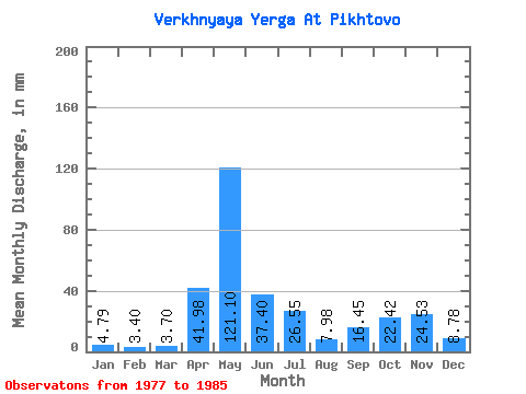
| Statistic | Jan | Feb | Mar | Apr | May | Jun | Jul | Aug | Sep | Oct | Nov | Dec | Annual |
|---|---|---|---|---|---|---|---|---|---|---|---|---|---|
| Mean | 4.79 | 3.43 | 3.69 | 41.98 | 121.08 | 37.40 | 26.54 | 7.97 | 16.45 | 22.43 | 24.53 | 8.78 | 317.71 |
| Standard Deviation | 1.58 | 0.88 | 1.07 | 41.46 | 49.88 | 34.50 | 26.18 | 5.35 | 12.83 | 13.38 | 17.76 | 4.83 | 66.08 |
| Min | 3.32 | 2.49 | 2.44 | 4.73 | 35.58 | 7.57 | 3.32 | 2.74 | 3.88 | 7.23 | 8.80 | 4.59 | 238.91 |
| Max | 7.82 | 4.81 | 6.06 | 125.82 | 214.04 | 93.56 | 71.45 | 18.18 | 36.23 | 45.25 | 56.19 | 20.52 | 424.83 |
| Coefficient of Variation | 0.33 | 0.26 | 0.29 | 0.99 | 0.41 | 0.92 | 0.99 | 0.67 | 0.78 | 0.60 | 0.72 | 0.55 | 0.21 |
 Return to R-Arctic Net Home Page