|
|
|||||||||||||||||
| Point ID: 8906 | Downloads | Plots | Site Data | Code: 70567 |
|
|
|||||||||||||||||
| Download | |
|---|---|
| Site Descriptor Information | Site Time Series Data |
| Link to all available data | |
| View: | Time Series | All |
| Units: | mm |
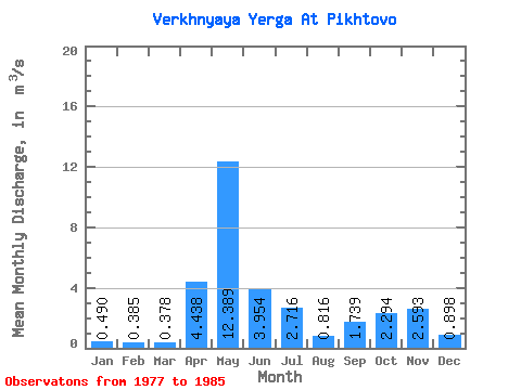
| Statistic | Jan | Feb | Mar | Apr | May | Jun | Jul | Aug | Sep | Oct | Nov | Dec | Annual |
|---|---|---|---|---|---|---|---|---|---|---|---|---|---|
| Mean | 0.49 | 0.39 | 0.38 | 4.44 | 12.39 | 3.95 | 2.72 | 0.82 | 1.74 | 2.29 | 2.59 | 0.90 | 2.76 |
| Standard Deviation | 0.16 | 0.10 | 0.11 | 4.38 | 5.10 | 3.65 | 2.68 | 0.55 | 1.36 | 1.37 | 1.88 | 0.49 | 0.57 |
| Min | 0.34 | 0.28 | 0.25 | 0.50 | 3.64 | 0.80 | 0.34 | 0.28 | 0.41 | 0.74 | 0.93 | 0.47 | 2.07 |
| Max | 0.80 | 0.54 | 0.62 | 13.30 | 21.90 | 9.89 | 7.31 | 1.86 | 3.83 | 4.63 | 5.94 | 2.10 | 3.69 |
| Coefficient of Variation | 0.33 | 0.26 | 0.29 | 0.99 | 0.41 | 0.92 | 0.99 | 0.67 | 0.78 | 0.60 | 0.72 | 0.55 | 0.21 |
 Return to R-Arctic Net Home Page