|
|
|||||||||||||||||
| Point ID: 8853 | Downloads | Plots | Site Data | Code: 70282 |
|
|
|||||||||||||||||
| Download | |
|---|---|
| Site Descriptor Information | Site Time Series Data |
| Link to all available data | |
| View: | Time Series | All |
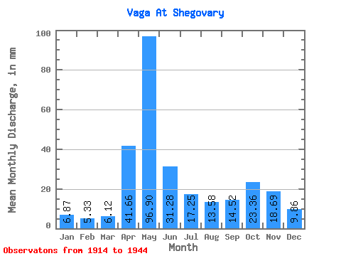
| Units: | m3/s |
| Statistic | Jan | Feb | Mar | Apr | May | Jun | Jul | Aug | Sep | Oct | Nov | Dec | Annual |
|---|---|---|---|---|---|---|---|---|---|---|---|---|---|
| Mean | 6.87 | 5.38 | 6.11 | 41.66 | 96.89 | 31.28 | 17.25 | 13.58 | 14.52 | 23.36 | 18.69 | 9.86 | 287.08 |
| Standard Deviation | 2.31 | 1.53 | 1.60 | 24.75 | 37.70 | 16.65 | 10.27 | 11.17 | 11.44 | 16.65 | 12.32 | 3.95 | 69.71 |
| Min | 3.56 | 3.31 | 4.38 | 5.27 | 19.26 | 7.76 | 5.74 | 3.48 | 3.10 | 3.47 | 3.24 | 3.30 | 164.77 |
| Max | 13.77 | 11.57 | 12.32 | 101.48 | 178.11 | 77.03 | 48.13 | 51.48 | 52.76 | 89.06 | 59.79 | 16.80 | 441.16 |
| Coefficient of Variation | 0.34 | 0.28 | 0.26 | 0.59 | 0.39 | 0.53 | 0.59 | 0.82 | 0.79 | 0.71 | 0.66 | 0.40 | 0.24 |
 Return to R-Arctic Net Home Page