|
|
|||||||||||||||||
| Point ID: 8853 | Downloads | Plots | Site Data | Code: 70282 |
|
|
|||||||||||||||||
| Download | |
|---|---|
| Site Descriptor Information | Site Time Series Data |
| Link to all available data | |
| View: | Time Series | All |
| Units: | mm |
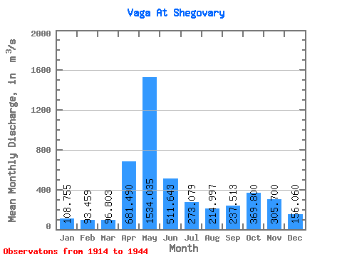
| Statistic | Jan | Feb | Mar | Apr | May | Jun | Jul | Aug | Sep | Oct | Nov | Dec | Annual |
|---|---|---|---|---|---|---|---|---|---|---|---|---|---|
| Mean | 108.75 | 93.46 | 96.80 | 681.49 | 1534.04 | 511.64 | 273.08 | 215.00 | 237.51 | 369.80 | 305.70 | 156.06 | 385.69 |
| Standard Deviation | 36.58 | 26.55 | 25.35 | 404.92 | 596.84 | 272.40 | 162.58 | 176.80 | 187.21 | 263.55 | 201.48 | 62.55 | 93.65 |
| Min | 56.40 | 57.60 | 69.40 | 86.20 | 305.00 | 127.00 | 90.80 | 55.10 | 50.70 | 55.00 | 53.00 | 52.30 | 221.36 |
| Max | 218.00 | 201.00 | 195.00 | 1660.00 | 2820.00 | 1260.00 | 762.00 | 815.00 | 863.00 | 1410.00 | 978.00 | 266.00 | 592.69 |
| Coefficient of Variation | 0.34 | 0.28 | 0.26 | 0.59 | 0.39 | 0.53 | 0.59 | 0.82 | 0.79 | 0.71 | 0.66 | 0.40 | 0.24 |
 Return to R-Arctic Net Home Page