|
|
|||||||||||||||||
| Point ID: 8827 | Downloads | Plots | Site Data | Code: 70025 |
|
|
|||||||||||||||||
| Download | |
|---|---|
| Site Descriptor Information | Site Time Series Data |
| Link to all available data | |
| View: | Time Series | All |
| Units: | m3/s |
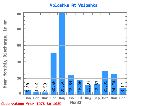
| Statistic | Jan | Feb | Mar | Apr | May | Jun | Jul | Aug | Sep | Oct | Nov | Dec | Annual |
|---|---|---|---|---|---|---|---|---|---|---|---|---|---|
| Mean | 5.29 | 3.05 | 2.59 | 50.55 | 99.49 | 23.54 | 18.06 | 11.87 | 12.87 | 29.02 | 24.74 | 8.17 | 286.53 |
| Standard Deviation | 3.81 | 1.63 | 1.15 | 57.11 | 43.44 | 20.58 | 16.57 | 19.21 | 15.16 | 23.45 | 13.27 | 3.97 | 62.80 |
| Min | 1.41 | 1.13 | 1.08 | 4.24 | 29.37 | 4.70 | 1.99 | 0.87 | 1.61 | 5.39 | 9.13 | 3.11 | 214.60 |
| Max | 12.02 | 5.28 | 4.16 | 162.00 | 161.29 | 70.98 | 46.79 | 58.43 | 46.76 | 60.94 | 41.90 | 13.85 | 366.50 |
| Coefficient of Variation | 0.72 | 0.54 | 0.44 | 1.13 | 0.44 | 0.87 | 0.92 | 1.62 | 1.18 | 0.81 | 0.54 | 0.49 | 0.22 |
 Return to R-Arctic Net Home Page