|
|
|||||||||||||||||
| Point ID: 8827 | Downloads | Plots | Site Data | Code: 70025 |
|
|
|||||||||||||||||
| Download | |
|---|---|
| Site Descriptor Information | Site Time Series Data |
| Link to all available data | |
| View: | Time Series | All |
| Units: | mm |
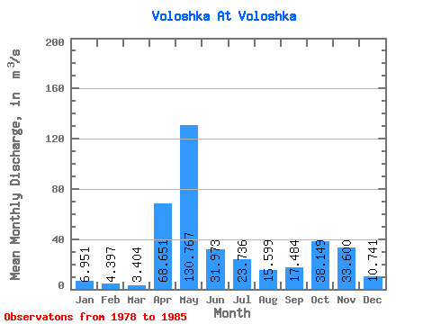
| Statistic | Jan | Feb | Mar | Apr | May | Jun | Jul | Aug | Sep | Oct | Nov | Dec | Annual |
|---|---|---|---|---|---|---|---|---|---|---|---|---|---|
| Mean | 6.95 | 4.40 | 3.40 | 68.65 | 130.77 | 31.97 | 23.74 | 15.60 | 17.48 | 38.15 | 33.60 | 10.74 | 31.96 |
| Standard Deviation | 5.01 | 2.35 | 1.51 | 77.55 | 57.10 | 27.95 | 21.78 | 25.25 | 20.59 | 30.83 | 18.02 | 5.22 | 7.00 |
| Min | 1.85 | 1.63 | 1.42 | 5.76 | 38.60 | 6.38 | 2.61 | 1.14 | 2.19 | 7.08 | 12.40 | 4.09 | 23.93 |
| Max | 15.80 | 7.61 | 5.47 | 220.00 | 212.00 | 96.40 | 61.50 | 76.80 | 63.50 | 80.10 | 56.90 | 18.20 | 40.88 |
| Coefficient of Variation | 0.72 | 0.54 | 0.44 | 1.13 | 0.44 | 0.87 | 0.92 | 1.62 | 1.18 | 0.81 | 0.54 | 0.49 | 0.22 |
 Return to R-Arctic Net Home Page