|
|
|||||||||||||||||
| Point ID: 882 | Downloads | Plots | Site Data | Code: 07FB003 |
|
|
|||||||||||||||||
| Download | |
|---|---|
| Site Descriptor Information | Site Time Series Data |
| Link to all available data | |
| View: | Time Series | All |
| Units: | m3/s |
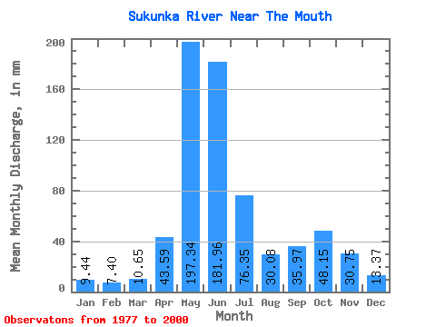
| Statistic | Jan | Feb | Mar | Apr | May | Jun | Jul | Aug | Sep | Oct | Nov | Dec | Annual |
|---|---|---|---|---|---|---|---|---|---|---|---|---|---|
| Mean | 9.44 | 7.47 | 10.65 | 43.59 | 197.31 | 181.96 | 76.34 | 30.08 | 35.97 | 48.15 | 30.75 | 13.37 | 681.30 |
| Standard Deviation | 3.13 | 3.19 | 6.82 | 22.47 | 58.20 | 59.18 | 32.40 | 16.05 | 29.30 | 27.55 | 17.91 | 4.51 | 111.36 |
| Min | 5.72 | 4.12 | 4.19 | 8.42 | 95.38 | 60.62 | 33.61 | 8.48 | 7.89 | 22.30 | 10.09 | 7.37 | 455.06 |
| Max | 17.50 | 18.18 | 33.82 | 91.50 | 317.95 | 302.57 | 153.64 | 84.29 | 104.30 | 119.50 | 80.96 | 26.78 | 998.53 |
| Coefficient of Variation | 0.33 | 0.43 | 0.64 | 0.52 | 0.29 | 0.33 | 0.42 | 0.53 | 0.81 | 0.57 | 0.58 | 0.34 | 0.16 |
 Return to R-Arctic Net Home Page