|
|
|||||||||||||||||
| Point ID: 882 | Downloads | Plots | Site Data | Code: 07FB003 |
|
|
|||||||||||||||||
| Download | |
|---|---|
| Site Descriptor Information | Site Time Series Data |
| Link to all available data | |
| View: | Time Series | All |
| Units: | mm |
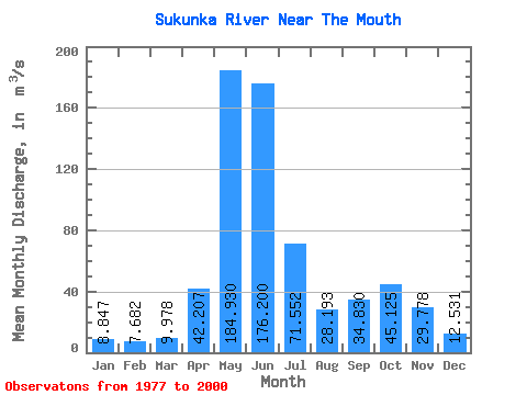
| Statistic | Jan | Feb | Mar | Apr | May | Jun | Jul | Aug | Sep | Oct | Nov | Dec | Annual |
|---|---|---|---|---|---|---|---|---|---|---|---|---|---|
| Mean | 8.85 | 7.68 | 9.98 | 42.21 | 184.93 | 176.20 | 71.55 | 28.19 | 34.83 | 45.12 | 29.78 | 12.53 | 54.19 |
| Standard Deviation | 2.93 | 3.28 | 6.39 | 21.76 | 54.55 | 57.31 | 30.36 | 15.04 | 28.37 | 25.82 | 17.34 | 4.23 | 8.86 |
| Min | 5.36 | 4.24 | 3.93 | 8.15 | 89.40 | 58.70 | 31.50 | 7.95 | 7.64 | 20.90 | 9.77 | 6.91 | 36.19 |
| Max | 16.40 | 18.70 | 31.70 | 88.60 | 298.00 | 293.00 | 144.00 | 79.00 | 101.00 | 112.00 | 78.40 | 25.10 | 79.41 |
| Coefficient of Variation | 0.33 | 0.43 | 0.64 | 0.52 | 0.29 | 0.33 | 0.42 | 0.53 | 0.81 | 0.57 | 0.58 | 0.34 | 0.16 |
 Return to R-Arctic Net Home Page